


 Inglés (pdf)
 Articulo en XML
 Referencias del artículo
 Enviar articulo por email
 Citado por SciELO
  Similares en
SciELO
Similares en
SciELO 
 Permalink
Introduction
Cuautlancingo municipality, part of the Puebla-Tlaxcala Metropolitan Area, is located in the northwest of the City of Puebla. Its territorial development origins were closely tied to agricultural production. However, due to economic processes in Mexico that unfolded in the mid-20th century, it adapted to meet the new needs of modern society. Its territory underwent reconfiguration to encompass various forms of production, aiming to supply and align with global market demands.
This municipality began its territorial transformation process in the late 1950s, with large areas primarily dedicated to agricultural use, comprising 98,55% of its total 34,24 km² surface area, while urban areas accounted for only 0,50%. This situation changed around 1958 with the construction of the Mexico-Puebla highway, which contributed to urban sprawl and connected several urban areas in the state of Puebla (Tochihuitl et al., 2016). However, the watershed moment came in 1966 with the establishment and development of the industrial zone and the arrival of the Volkswagen automotive industry, creating a hub of economic development that led to the emergence of new residential and industrial zones on formerly ejidal (communal land) agricultural areas. This transformation favoured changes in land use, where these low-cost lands led to land speculation and the issuance of construction permits for the establishment of industrial zones in a disorderly manner, which in turn accelerated urban growth (Cabrera-Becerra et al., 2008).This shift was reflected in a significant decrease in agricultural areas by 30%, while urban areas notably increased to 42,13%, along with the gradual emergence of industrial zones accounting for 24,28%, according to the Population and Housing Census of the National Institute of Statistics and Geography (INEGI, 2020).
The above developments affected one of the main localities within the municipality known as San Juan Cuautlancingo, which is composed of four neighbourhoods: Barrio del Bajío, Barrio del Perdón, Barrio del Calvario, and Barrio del Alto. With the emergence of new residential areas, lifestyles and traditions have undergone transformation. Residents of these new residential complexes often do not appreciate the use of public spaces for various socio-cultural and religious expressions such as processions, patron saint festivals, and various cultural events. These activities form part of the historical and identity heritage of these neighbourhoods.
Therefore, the objective is to demonstrate how urban expansion through changes in land use has interfered with the socio-spatial valuation between the residents of the San Juan neighbourhood and the new residential areas. This interference manifests in the use, access, and appropriation of public spaces by various socio-cultural and religious expressions, such as those observed along Avenida Morelos.
Methodological process
The methodological process of the research adopts a mixed-method approach involving the collection, analysis, and linkage of quantitative and qualitative data to address the problem at hand (Hernández and Mendoza, 2018). This approach systematically integrates the information gathered to obtain a more comprehensive understanding of the situation under analysis.
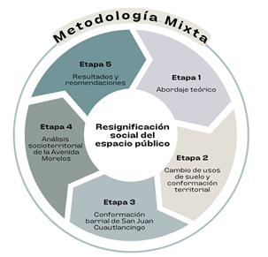
The methodological process unfolded in stages, beginning with the identification of various authors to understand theoretical perspectives on urban growth, land use changes, public space, and the valuation of cultural expressions. In the second phase, changes in land use in the municipality were examined for two periods: 1990 and 2020, using spatial analysis in Geographic Information Systems (GIS) based on urban cartography and land use maps from INEGI. Satellite imagery with a resolution of 100 meters was employed to identify new residential complexes. The third stage focused on the neighbourhood composition of San Juan Cuautlancingo and identified major conflicts within its neighbourhoods. The fourth stage involved a socio-territorial analysis of processes, interactions, and social conflicts occurring in public spaces of San Juan Cuautlancingo, particularly the appropriation of Avenida Morelos. A map was created to locate the main routes used by both original residents and residents of new residential complexes, identifying conflict points. Additionally, the social perspective of residents on urban issues was explored through semi-structured surveys comprising 24 questions grouped into two sections: citizen participation and neighbourhood organization. In the fifth and final stage, the findings were presented in the conclusions and recommendations section based on the insights gathered throughout the research process (Figure 1).
Theoretical approach to the valuation of public space. A way of understanding socio-cultural spaces
The urban environment of public spaces is not only characterized by its physical conditions but also by the way it has been appropriated for social benefit, emanating from the major spheres of power such as institutions, both public and private, and as Vargas Aguirre (2018) suggests, from the everyday practices that each group develops in the specific territories in which they live. Appropriation in this case is a multidimensional process that takes place in social spaces. These are determined by the availability of goods and possible practices (Bourdieu, 2011). Consequently, public spaces are also constructed by external and internal processes of territorial appropriation.
Similarly, Segovia (2007) reminds us that public space is also the territory where the crisis of city life often manifests broadly. It is one of the areas where the social, cultural, and political positions and contradictions of a society and a particular era converge and are expressed. According to this author, we must consider public space in an even broader sense: as a physical, symbolic, and political stage that contributes to giving meaning to people's urban life, from learning and the respective generation of social practices to preserve them.
While public space is the constructed space where certain social life processes occur, which seemingly give content to that dimension of space constituted by its own physical materiality (Correa, 2020), streets and avenues are, in this case, important territorial elements where the most prominent social potentials of communities, both material and immaterial, are integrated. These are constituted by a political order for their mediation, administration, utilization, and appropriation.
However, many residents and social groups continue to resist such displacement, asserting their right to expression and social recreation to preserve their tangible and intangible heritage. Consequently, these differences often result in unique forms of territorial disputes and juxtaposed methods of reinterpreting these spaces, thereby creating complex territories marked by conflicts and negotiations. Within these territories, hegemonic and subaltern ways of inhabiting and utilizing the spaces coexist and interact (Wahren, 2011).
From the latter, the material and immaterial properties of public spaces are indicators that show the socio-spatial value attributed by individuals, communities, or social groups through appropriation. According to Tomadoni and Romero Grezzi (2014), these spaces are inhabited by unique social agents who act in a particular way, ultimately developing their own identity and distinctive materiality. Their dynamics express the principles, paradoxes, conflicts, and solutions that a society has produced around the central challenge of how to organize itself materially and how relationships among its members develop (Schlack & Araujo, 2022).
In addition, the urban encroachment on rural settlements without regulatory measures warns of the proliferation of factors that displace the lifestyles of the original inhabitants. The contrasts generated by this process result in contradictions that can only be understood in the context of the inequality brought about by the arrival of new inhabitants to the territory (Hernández-Flores, 2023). This means that ways of life primarily associated with urban areas are imposed, and consequently, the demands for public services and infrastructure are aimed at meeting those needs. This leads to the displacement of appropriation mechanisms that the original inhabitants were accustomed to, which are fundamental to their cultural context.
The convergence of the physical and symbolic aspects in public spaces is revealing challenges that result in a marked differentiation among the population due to their various forms of socio-spatial production influenced by urban encroachment. Consequently, social inequalities emerge, leading to fragmentation that becomes evident in environments where public life is generated. This reveals a series of social contrasts in the occupation and production of streets and avenues.
4. Results. Impact of land use change on socio-cultural activities in the neighbourhood of San Juan Cuautlancingo
Urban expansion is a trend that manifests in the surpassing of pre-existing urban limits, merging with rural areas and leaving vacant or semi-vacant spaces between them. These processes drastically affect the environmental surroundings and agricultural zones due to changes in land use (De Mattos, 2001; Romero et al., 2003). As a result, human activities have transformed the territory and severely altered the environment. The most pronounced trend involves replacing natural soil and vegetation with urban areas, excessive agricultural practices, the creation of industrial zones, and the expansion of urban centers (Zepeda et al., 2012; Jarvis & Young, 2008).
4.1 Land use changes and their new territorial configuration
The territory is the space where culture is inscribed, marked by the traces and imprints left by those who inhabit it. It is also "a space that holds memories; each culture has a different way of appropriating its territory, leaving marks through its customs, daily activities" (Guevara, 2014, p. 92). Therefore, it is necessary to understand the land use changes that have occurred in the territorial appropriation in the municipality of Cuautlancingo, as these changes reflect trends and dynamics in land use, providing elements that contribute to territorial transformations.
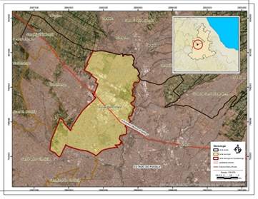
The municipality of Cuautlancingo is located in the central part of the state of Puebla, as shown in Figure 2. It covers an area of 34,24 km2. Around the 1950s, it was predominantly composed of large agricultural zones, accounting for approximately 98,55% of the area, while urban zones only occupied 0,50%, mostly consisting of ejido lands. However, the situation changed with the need to connect major cities, leading to the construction of the Mexico-Puebla highway in 1958, which initiated the process of urban conurbation in this area (Tochihuitl et al., 2016). The significant change occurred with the establishment of the Volkswagen automotive industry, creating a hub of economic development that spurred the emergence of new residential and industrial zones. This development led to land speculation and the issuance of construction permits without regulatory measures, resulting in uncontrolled urban expansion and irreversible changes to the municipality's territory. Meanwhile, residential and industrial areas caused land use to adapt to their new purposes.
Schumacher emphasizes that the negligence in authorizing land use changes in this municipality, the interest of real estate developers in investing in cheap land and quickly building on it, as well as the lack of a comprehensive territorial vision from those who have governed this municipality in the last 30 years, are some of the causes of this problem. On the other hand, Flores argues that the current urban growth is surpassing any municipal authority, especially due to the lack of regulatory coordination, as regulations are not as strong as in the city of Puebla (in Hernández, 2024).
It is essential to mention that,
land speculation is associated with the indiscriminate conversion of rural lands for urban use in the peripheries. This phenomenon is compounded by a growing dependence on individual vehicles and lifestyles of the new middle class, which expands the shape of urban areas beyond the limits of formal cities (Martínez et al., 2020, p. 154).
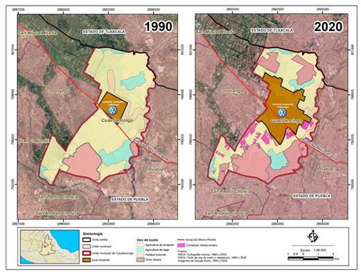
In the map shown in Figure 3, two time series are presented regarding land use in the 1990s and 2000s based on land use and vegetation maps from INEGI. By 1990, the industrial zone that originated around the 1960s was already consolidated, and it expanded fourfold from 6,34% to 24,28% by 2020, occupying areas previously used for seasonal agriculture and induced pasture. On the other hand, urban areas expanded into agricultural regions, increasing from 13,03% to 42,13%, while agricultural zones drastically decreased from 62% in 1990 to 27,70% in 2020, marking a threefold reduction in their territorial extent.
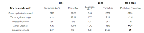
The municipality's losses and gains are expressed in a decrease of 11,83km2 in seasonal agricultural areas, 3,41km2 in irrigated agriculture zones, and 0,86km2 in induced pasture, while the increase occurred in urban areas by 9,96 km2 and in industrial zones by 6,14 km2 as shown in Table 1. The above illustrates the trend and land use change that has occurred in the last three decades, which constitutes the spatial expression of the municipality's land use, showcasing spatial patterns lacking planning for this territory. This has also been reflected in population growth, which from 2010 to 2020 has increased by 73%, reaching 137,435 inhabitants with a population density of 3,602.9 inhabitants/km2 (INEGI Population and Housing Census, 2020), positioning it as one of the municipalities nationally with the highest growth in population density.
Source: INEGI (1990, 2000).
Table 1: Chart of trends, losses, and gains in land use in the municipality of Cuautlancingo 1990, 2020.
The variation in surface areas between one period and another shows the trend of land use change, particularly in the southwest and central parts of the municipality, where several residential complexes were developed such as El Lucero, Celestum, Alce, Ángeles, Las Américas, Porto Alegre, La Sierra, among others, occupying 5% of the total area of the municipality. Unfortunately, this has led to this area becoming a "bedroom community, due to the availability of low-cost housing" (Hernández, 2024, p. 1). An example is shown in Figure 4:
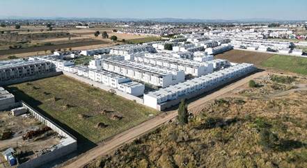
Source: González (2024).
Figure 4: Housing complexes in the south of the municipality of Cuautlancingo.
San Juan Cuautlancingo is composed of four neighborhoods: El Bajío, El Perdón, El Calvario, and El Alto. Historically, each neighborhood formed into communities divided by barrios under the leadership of calpullis1, creating a political and cultural system that originates from ancient civilizations and their respective process of colonization. This is part of the historical formation as a community of indigenous origin, whose practices still prevail through religious rituals such as processions, which take place every year on the most commemorative dates of the municipality (Águila, 2023).
In this regard, some representative social groups from the neighbourhoods, known as loading systems or mayordomías, have played a significant role in the management, administration, and execution of religious festivities. For generations, they have exercised their right of territorial appropriation to maintain their traditional festivities, managing to survive in urban public spaces.
The cargo(loading) system is the political-religious structure that constitutes the core of the community. It is the axis through which the requirements of belonging are established, meaning the conditions of community citizenship. From this, a collective identity is defined, expressed in a worldview that places the community itself as the cosmic centre. This ethnocentrism is manifested in a dialectal variant of the spoken Amerindian language, but above all, in a specific patron saint and an annual ceremonial cycle (Paleta, 2014, p. 97).
In San Juan Cuautlancingo, there is a colonial-style Baroque parish dating back to the 16th century, where Saint John the Baptist is venerated. This parish serves as the starting and/or concluding point for the community's liturgical activities.
4.3 Conflicts in the routes of the main roads in the neighbourhoods
The formation of the community of Cuautlancingo does not follow a homogeneous process of identity relations. Instead, it can be considered a set of relationships that share labor, social, and political habits, allowing them to organize and share common interests in an environment where they are still permitted to have control over public spaces due to their legitimacy and cultural contribution to the territory.
Furthermore, a space becomes complex when social rationalities intensify to occupy a shared space, particularly public spaces in this case. Urban experiences are centered around urban public life, with streets being at the heart of inquiries (Szpac, et al., 2015). Thus, in the dynamics of territorial intervention, both institutional and collective, there are situations where social appropriation habits are introduced, conditioned by economic and political processes. These processes draw from cultural representation that converges in the forms of coexistence within public spaces. These activities have been affected on the main avenues connecting these neighborhoods by residents who temporarily reside due to their proximity to the Volkswagen industry. Their use of public space does not always align with the socio-cultural and religious expressions that form part of the historical and identity heritage of these neighborhoods.
Some of the routes are between the Chapel of El Alto, Chapel of El Bajío, Chapel of El Perdón, Chapel of El Calvario, and the Parish of San Juan Bautista. These routes, during their religious events between the neighborhoods, primarily take place on avenues such as Morelos, Miguel Hidalgo, 20 de Noviembre, San Juan, and streets like Moctezuma, Uranga, and 5 de Mayo. Certain processions and festivities held at various times of the year obstruct and close off streets, as depicted in Figure 6.
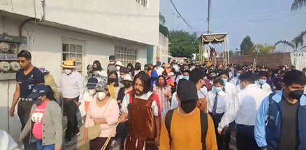
Source: PB Communication, (2024).
Figure 5: Closure of Avenida 20 de noviembre in the neighbourhood of Perdón.
Part of the conflicts that arise between residents of residential complexes or neighbourhoods is due to residents of the neighbourhoods occupying avenues or streets, sometimes closing them off to conduct their festivities. This situation is not well-received by residents of the residential complexes who use these streets for passage, Figure 5 presents a spatial analysis of the routes in the area: religious routes are marked in purple, while frequent routes used by residents of the residential complexes are marked in yellow. Red dots indicate conflict points detected during field surveys that cause traffic problems and displacement, leading to annoyance and a lack of empathy towards these religious or sociocultural expressions. Additionally, the map highlights Morelos Avenue in red, belonging to the Alto neighbourhood, which hosts significant commercial activities.
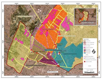
Source: Aguila, (2023) and INEGI, (2023).
Figure 6: Neighbourhoods of the municipality of San Juan Cuautlancingo.
4.4 Appropriation of public space on Morelos Avenue
Morelos Avenue is a two-way road that experiences constant traffic of vehicles and pedestrians due to the large number of informal businesses distributed along it and the occurrence of traditional festivities that involve its partial closure. On one hand, it reflects a contextual reality reinforced by cultural representation, while on the other hand, it portrays a heterogeneous spatial perspective associated with the phenomenon of urbanization, as shown in Figure 7. The avenue consists of 122 properties, out of which 78 have been converted for commercial use (National Statistical Directory of Economic Units, INEGI, 2022). Urban measures undertaken by the municipality, particularly those related to the appropriation of public space for commerce, are not readily available. Consequently, there is a lack of control over mixed land use observed along this avenue, where residential properties have been adapted for commercial purposes.
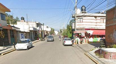
As a result, the distribution of commercial units along the roadways, appropriated without regulation, obstructs pedestrian passage. This situation compels people to navigate other areas that compromise their safety. The issue persists within daily practices undertaken by residents in response to existing demand, particularly for services. Consequently, the need for safety in daily commutes often takes a back seat. It's worth noting that despite the municipality's recent productive development, there remains a significant scarcity of accessible services for residents. In response, there has been a social adaptation where some residential properties are converted into informal businesses. This adaptation serves as a means to address the lack of public services provided by institutions.
Informal businesses run by household groups play a crucial role in the socio-economic development of the neighbourhoods. They directly and indirectly meet the needs of sellers, producers, and consumers, serving as major acquisition points within specific communities. Operating in strategic areas of public space to reach a broader consumer base, these businesses operate without regulation. Residents along these avenues demonstrate irregularities in how they access and appropriate public space, highlighting inconsistencies and discrepancies in its use.
4.5 Social perception assessment in the appropriation of public space
Pérez (2024) states that "public space plays a fundamental role in the construction of territory, not only articulating, structuring, and organizing different activities and uses of urban space, but also being the quintessential stage for the collective socialization of the city" (p. 29). Therefore, the use of this space is conceived based on the needs of each social group, as its use is considered a right that cannot be alienated or lost.
The public spaces formed by the streets and avenues in the locality of San Juan Cuautlancingo have been transformed in accordance with territorial processes influenced by industrial integration and residential complexes. Areas that were once ejidos (communal land) and rural environments have evolved into unplanned urban settlements.
In these cases, public space is perceived and defined as a space for everyone, accessible to all. In most instances, the average citizen does not perceive public space at the city scale but rather at smaller scales such as the neighbourhood and locality (Pérez, 2004, p. 31).
In order to know the perception of the inhabitants regarding the situation of the use of public space, the following are some of the twenty interviews conducted with community stakeholders who authorized the use of their answers anonymously:
Interview 1. Anonymous, 63-year-old resident of the avenue, states the following:
"Previously, it was an area where you could still see many processions on all the streets leading to the chapels of what used to be the town. But recently, that's almost disappeared because the people who started arriving, who are not from here, are not part of that atmosphere".
Interview 2. Anonymous, 65-year-old resident with 44 years living in the community, comments:
"You know, when I remember the avenue, it was very different from how we see it now. I remember that before, we all used to help each other, but now I barely know the people who live around here because either they moved away or have passed away (laughs), and I think the avenue has changed because more cars started coming in, more transportation, and more people arrived".
Interview 3. Anonymous, 40-year-old temporary resident living in one of the residential complexes:
"I live in this area because it's close to my work. I only use the house to sleep in. It bothers me that when I'm in a hurry, I can't get out because they block the streets. They should prohibit their processions or parties".
Interview 4. Anonymous, 45-year-old resident, I have been living in this area for 2 years and I am tired of the lack of services in the area, besides they use their streets for religious purposes, it's not that I don't have religion but they respect others, on the other hand, trying to reach my house there is no way to park because there is a lot of trade that blocks my entrance.
The previous testimonies are a reflection of the incompatibility between long-time residents of neighbourhoods and those who live there temporarily or recently, highlighting discontent over the use of streets for religious activities, a situation that has been developing in these neighbourhoods for a long time.
In addition to the above, a semi-directed survey with 24 questions was conducted among 84 residents of the neighbourhoods to understand their perception of the use of public space. The survey was divided into two sections: social organization and participation in various socio-cultural and religious events. Below, we present the perception regarding activities in socio-cultural and religious events that take place, and whether residents participate in them.
Regarding participation in various events, 52% are religious, 33% are commercial, and 15% involve cultural, sports, and musical activities. In terms of organization, 50% stated they participate in organizing religious events, 25% in commercial activities, 15% in cultural events, and the remaining 10% in sports and musical events, as shown in Figure 8. This indicates that a significant portion of the respondents participates in religious activities.
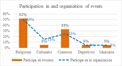
Source: Authors (2024)
Figure 8: Graph showing the participation of residents in socio-cultural and religious activities and their organization in San Juan Cuautlancingo.
In Figure 9, the responses regarding who is responsible for solving issues related to public spaces are presented. 50% responded that it depends on both municipal authorities and the population, 30% on the City Council, and 20% on the residents or neighbours. These results highlight the shared responsibility that residents have in the use of their space.
While there is a visible difference between the lifestyles of native residents and newcomers, the lack of comprehensive territorial vision is equally affecting them. This impact is evident not only in the lack of services but also in the growth of informal commerce, urban planning deficiencies, among other conflicts (Hernández, 2024, p. 2).
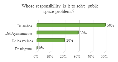
Source: Authors (2024)
Figure 9: Graph asking about the solution for public space in San Juan Cuautlancingo.
Urban impact differs mainly in the social development discourses embraced by current government institutions. As urban problems continue to interconnect, the reality of these new urban contexts often fails to align with their development objectives. Consequently, the socio-spatial transformation of public spaces like streets reflects how communities have internalized these issues, making them part of their daily lives and shared spaces despite existing conflicts.
5. Conclusion
Urbanization over communities with agricultural backgrounds presents a profound complexity that adversely affects social fabric. Consequently, one of the major challenges faced by the territory is the scarce political intervention measures aimed at benefiting the entire society. This research has demonstrated how urban expansion has overflowed into rural areas of the municipality of Cuautlancingo in recent decades, blurring the distinction between urban and rural through gradual, intangible, and fluid interactions between both. This juxtaposition has proliferated in areas adjacent to the neighbourhoods of San Juan Cuautlancingo, with the emergence of housing complexes conflicting with the use, access, and appropriation of public space expressed by the residents of these neighbourhoods through their sociocultural and religious expressions.
To verify this process, it was necessary to understand the change in land use over the past three decades. Through these changes, it became possible to identify, quantify, analyse, and describe the dynamics of change within a specific period between 1990 and 2020. Among the main findings, the urban area of the zone tripled its surface area, positioning the municipality nationally as one of the fastest-growing in population density due to urbanization processes. Additionally, the industrial zone around the Volkswagen automotive plant quadrupled due to labour demand for both general and specialized workforce, which subsequently led to a demand for housing. This resulted in the emergence of various residential complexes, particularly in the southwest part of the municipality. These changes reflect the spatial expression of land use in the municipality, characterized by spatial patterns that have reduced agricultural areas.
Consequently, the population increase has been marked by the arrival of residents to new residential complexes who are unfamiliar with the sociocultural expressions of the original inhabitants of the neighbourhoods. This situation underscores the pivotal role of public space, as both its tangible and intangible properties serve as indicators that demonstrate the socio-spatial valorisation conferred by individuals or social groups through their appropriation. This contrasts with the perspective of newcomers, who often arrive temporarily. In the municipality of Cuautlancingo, there exists a complex web of relationships that share labour, social, and political habits, enabling them to organize around common interests in an environment where there is still a dominance over public spaces due to their legitimacy and cultural contribution to the territory.
Therefore, conflicts have arisen over the appropriation of public space due to sociocultural habits rooted in the cultural representation that shapes how the original population interacts within these spaces. The expressions found in religious processions, patron saint festivals, cultural events, and musical activities are integral to the historical and identity heritage of these neighbourhoods. These manifestations sometimes clash with the behaviours and expectations of newcomers who are unfamiliar with these ancestral ways of using public space, particularly when they attempt to navigate through areas used for sociocultural and religious activities during their daily routines. For instance, Avenida Morelos exemplifies this situation as it serves as a prominent thoroughfare blending commercial, religious, and cultural uses. Being one of the main exit routes, it often causes discontent among those passing through the area who may not understand or appreciate these cultural and religious activities occurring along the avenue.
Finally, this dichotomy between the original inhabitants and those who have arrived in recent years is a reflection of the lack of sociocultural appreciation that residents have shown over the years. It represents a challenge to achieve integration and establish a balance between both social groups, as each stratum values their public space differently. This challenge must be addressed not only by the residents themselves but also by local authorities, who need to recognize that there are diverse perspectives on life and the construction of social spaces within their territory. Public spaces should not be limited solely to mobility purposes. Therefore, it is crucial to revalue local appropriation through municipal guidelines to effectively manage these spaces. This approach aims to highlight the complexity faced by communities undergoing urbanization processes, recognizing it as a crucial phenomenon that continuously transforms the territory.
6. Recommendations
The process of organizing and valuing public space should begin with genuine knowledge and individual commitment. Political decisions are needed to promote the importance of achieving common objectives based on general principles for appropriating and using these spaces, regardless of one's role within them. However, it is crucial to establish the conditions necessary to achieve this goal.
Firstly, decisions should not solely be based on individual opinions but on prior knowledge that integrates personal experience and objective information regarding facts, programs, projects, or circumstances relevant to the shared environment. This approach requires solid institutional support from the outset. However, there is a challenging difficulty in generalizing the diverse experiences shared by communities to integrate them into proposals that benefit the majority, considering the varied social contexts and precedents to which each resident, social group, or community responds.
Therefore, secondly, the scope of that knowledge must encompass the general conception of factors that exist based on the individual conception of the inhabitants. This is crucial in achieving the disposition of the social sector in urban planning projects that address street and/or avenue infrastructure. It is essential to recognize the socio-spatial valorization that inhabitants place on their use, access, and appropriation of public space to identify similarities and differences in problem detection. This integration should include not only the belief systems related to their surroundings but also allow for the identification of the cultural contexts to which they respond.
Finally, the study of public spaces and their various types should extensively consider the characteristics of their temporal and spatial dimensions of recognition. This recognition allows us to register the development of a territory not only through its physical, geographic, or environmental properties but also through understanding the social development of the community within spaces conducive to public life. Consequently, urban interventions aimed at improving and maintaining such public spaces will be more effective.

