


 Espanhol (pdf)
 Artigo em XML
 Referências do artigo
 Enviar este artigo por email
 Citado por SciELO
  Similares em
SciELO
Similares em
SciELO 
 Permalink
1. Introduction
In the world, increasing pressure on the natural resources day by day, the problem of global climate change, the disturbance of the balance between the natural and built environment due to urbanization; all necessitated a reconsideration of the life cycle, which includes all production and consumption processes. Particularly in the late 1970s, environmental sensitivity towards ecological problems has increased and ecodesign has become a method for the reduction of environmental impacts of urbanization in different sectors and scales. The origin of the eco- design approach, which develops a holistic view of the problems of the modern world, can be traced back to Patrick Geddes’ integrated view of life at the beginning of the 20th century.
Environmental theorist Patrick Geddes conceived ‘place’ as the sum total of physical, economic and social components. For the first time, he conceptualized space by associating it with society and called social-ecological systems ‘organisms’ (Garau et al., 2016). He further stated that a healthy environment depends on the optimal performance of the interaction between organism, function and environment. The social and ecological systems, ‘organisms’ in Geddes’ terms, evolve in a cycle of ecological adaptation, which augments the resilience of ‘places’ (Geddes, 1915). The prefix of ‘eco’, which has its roots in the early 20th century and is used as a metaphor to describe all kinds of interaction of the system with itself and its environment, has been included in the design practices and processes over time. Ecological and sustainable design aims to ensure the self-sufficiency of the system for a healthy existence (Madge, 1993).
In this paper, the design and implementation process of the Outdoor Cinema and Activity Area Project, which is realized on one of the valley floors of the Main Campus of Mugla Sitki Koçman University (MSKU) that is considered as a part of a bigger social-ecological system, has been elaborated together with the eco-design approach that was adopted as a method of praxis during the process concerned. This method of praxis is based on the operationalization of the concepts of transect and panarchy, whose roots go back to the early 20th century works of Patrick Geddes.
With the aforementioned project, approximately 10 acres of idle land, which includes a rocky valley floor between the Faculty of Engineering and the Faculty of Science in the MSKU Main Campus Area, has been turned into an outdoor cinema and activity area that can be used by students through making it operational with an eco-design approach. Based on nature-human interaction, the project follows the traces of geography by adopting the transect approach, which is rooted in Geddes’ (1915) “Valley Section”, and evaluates the existing contours to create a design for a sustainable outdoor cinema and activity area in harmony with the environment. In the project, it is also aimed that the area planned as an outdoor cinema will provide a multi-functional framework that will allow different uses at different times.
In the subsequent section, the project area and the design approach are further explained together with the criteria used in the design and implementation of the project within a detailed context. It is followed by an elaboration of the components and the stages of implementation of the project. Accordingly, each component of the project is explained in relation to the design approach adopted and their stages of the implementation. The last section presents some concluding remarks in terms of operationalization of the design approach adopted in the project.
Method: Design approach and criteria
Mugla Sitki Koçman University Main Campus is located within the borders of Kotekli Neighborhood, located in the south of Mentese City, Mugla Province Center, Turkey, parallel to Mugla-Marmaris Highway (Figure 1). The Main Campus was established on a hilly area surrounding the western part of Mugla polje and has woodland tree clumps and maquis (Guner, 2001) in the southwest of Kotekli settlement established in Mugla polje, which is actually a karstic-based depression plain (Gul et al., 2021). There are valley beds formed by the surface and subsurface water flows from the hilly area to the polje within the campus area. These valleys, due to the permeable rocky ground structure in the campus, provide the flow of rain water to the lower Mugla and Karabaglar polje by infiltrating underground.

These valley beds have been an important input in the formation of the design criteria. The starting point here has been to create “an imagination” for an ecologically sustainable environment. The sources of this “imagination” can be traced back to the ‘Valley Section’ of Geddes (1915) when examined historically. Drawing on the ideas of Frédéric Le Play, a French mining engineer, sociologist, and economist (Beaver, 1962), in the valley section, Geddes emphasizes that sound planning decisions should be based on a detailed field survey covering an inventory of an area’s hydrology, geology, flora, fauna, climate, and natural topography, as well as its social and economic opportunities and challenges. In the subsequent parts of this section, the historical roots of the eco-design concept implemented in the study is presented together with the cross-fertilization of it with other basic concepts, and operationalization of the resulting framework in the study.
The Historical Roots of the Eco-Design Concept with Transect
While he was in France, Geddes attended a lecture delivered by Edmond Demolins, a follower of Le Play, in 1878 (Macdonald, 2020). In Le Play’s famous triad, Place-Work-Family, he discovered a connection between naturalistic and social studies which, in due course, paved the way for his regional survey (Macdonald, 2020; Munshi, 2022). This connection is manifested in Geddes’ (1915, p. 198) words as following; “Place, work, and folk - environment, function, and organism - are thus no longer viewed apart, but as the elements of a single process - that of healthy life for the community and the individual.”
In the method of the survey developed by Le Play, place, work and family were the basic units for the study of society. Place presents the environmental pressures and possibilities giving direction to the nature of the work which, in turn, regulates the organisation of the family. Contrarywise, the family’s needs and potentials determine the character of the work, which in turn gradually alters the environment (Munshi, 2022). Replacing family with people or folk, Geddes argued that geography (place), economics (work) and anthropology (folk) were so thoroughly connected that unification of them would produce valuable outcomes (Munshi, 2022).
In this regard, his ideas of spatial planning and design were based on the need for ‘survey before alteration’, a systematic sociological survey of a region (Munshi, 2022; Macdonald, 2020). As Macdonald (2020, p. 97) argues, Geddes develops not only a set of analytical categories (namely, place-work- folk) derived from Le Play, but also, as further elaborated in the subsequent part of this section, a set of emotional, intellectual and social methods (namely, sympathy-synthesis-synergy) allowing us to give practical meaning to those analytical categories within his main principle of co-operation.
In this context, actually, the first example of the transect approach, which emphasizes the continuity between nature and urban areas in the transition from rural to urban, is also observed in Geddes (Talen, 2002). Indeed, the valley section does not consider the natural environment against the built environment or the rural against the urban; but instead unites them with an idea of the valley section (Figure 2). Geddes illustrates physical conditions from mountainous ground to the shoreline. While he represents natural occupations and economic activities with some basic tools, he represents the changing graded natural geography according to the topography with plant drawings. He emphasizes the dominance of the natural environment on human settlements and the significance of basic economic interactions between human beings and the environment (Macdonald, 2020). Although the original valley section included only seven places and their corresponding occupations, in the subsequent works by the followers of Geddes, this simple section was improved with a diagrammatical representation of the physical structure of the environment by referring to the respective diagram as a ‘transect’ which is intentionally presented as an ideal type (Scott, 2016).
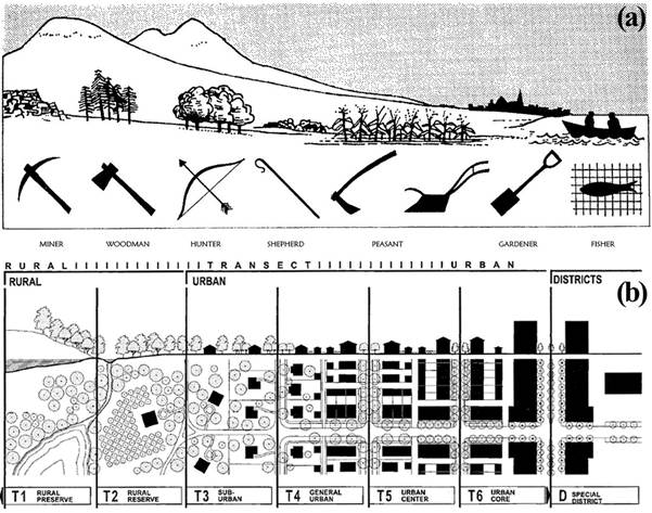
Source: P. Geddes (1915) and A. Duany (2005)
Figure 2: (a) Geddes’ 1909 valley section and (b) Duany’s 2005 transect system
With a focus on place-work-folk, the Valley Section Diagram reveals the need to analyse the environment in a holistic perspective. This holistic intention can be considered as a reflection of Geddes’ emblem of the three doves representing harmony and global peace in terms of his three S’s standing for ‘Sympathy, Synthesis and Synergy’. While ‘sympathy’ represents the need for emotional engagement, “the ability to accurately imagine oneself in another’s place, or to see oneself from another’s point of view”, ‘synthesis’ refers to the need for intellectual engagement, “the intellectual power of comparing and bringing into relation different ideas”, and as a societal notion ‘synergy’ means “acting together to solve problems and create opportunities” - cooperative engagement (MacDonald, 1994, p. 68). What follows from Geddes’ formulation is that a project can be meaningful only if it fulfils these three levels of engagement.
His valley section includes various types of spatial patterns adapting to their environment that refers to the social organization depending on the natural occupations (Welter, 2002). Among different spatial patterns, the transect approach provides the sustainability of the landscape by considering the in-depth understanding of a space in various scales and dimensions, thus providing a systematic analysis for spatial design (Han, 2021). As Han (2021) remarks, particularly, the planning discipline has used the transect concept to reveal the most appropriate relationship between the ecological setting and human settlement. This unified conception of the social and the ecological domains is actually completely in line with the traditionalist approach whose lineage can be traced back to the work of Geddes who argued that a city “grew out of its urban and rural environment in a complex web of causes and effects, its inter-related parts interwoven through time” (Ruttonsha, 2018, p. 206). Followers of Geddes such as Ian McHarg employed the transect as a tool for the establishment of human-ecological systems in spatial planning.
When the essence of Notation of Life diagram of Geddes is considered (Figure 3), Cloister, another important concept in Geddes’ analysis, gains importance as it provides us with some extra insights into the uniqueness of university campuses. In his terms, “from the Schools of all kinds of knowledge, past and present, we pass into the no less varied Cloisters of contemplation, meditation, imagination” (Geddes, 1905, p. 84). In addition to school, “a new development may arise, that which retires from the practical everyday life of a city, or even its everyday educational duties, into the meditative life in antique phrase, therefore, into ‘the cloister’, the ‘Abbey’ in later phrase into ‘intellectual retirement’” (Geddes, 1904, p. 219). In this context, Geddes identified additional correspondences between processes of the mental and cultural subsystems, and of ‘school’ and ‘cloister’ (Scott, 2016, p. 246).
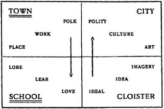
Source: P. Geddes (1905, p. 90)
Figure 3: Geddes’s four-fold analysis preceding his Notation of Life diagram
As Ghia (2021) argue, Geddes (1904; 1905; 1915) formulates the ‘cloister’ as the final ideal level based on the utopian line of thinking. With ‘cloister’ he refers to the site for universities, artist studios, art schools and public spaces functioning as the “central nervous system of government” and “its heart of spiritual tradition”, a place of contemplation, meditation, and imagination (Geddes, 1905; Geddes & Mears, 1911, p. 55). Thus, there are particular merits for an eco-design approach focusing on a university campus to draw on the concept of ‘cloister’. As Clavel & Young, (2017, p. 42) remark, according to Geddes, “city development was a discontinuous phenomenon, where many strands of ‘thought’ and ‘action’ occasionally came together in a critical and constructive juncture around the transition from ‘School’ to ‘Cloister’”.
Geddes’ and his followers’ efforts to integrate nature into urban planning and design have continued with the contemporary nature- based planning efforts covering “integrative efforts to adapt cities to climate change, sustainably manage natural resources, and restore degraded ecosystems” (LaGro, 2020, p. 74). In these efforts, the practical application of town planning principles of Geddes includes (Shoshkes, 2017); ‘diagnosis before treatment’ (i.e. survey before plan); ‘conservative surgery’ (i.e. rehabilitation rather than removal); and particularly, ‘bio-regionalism’ (i.e. people and place are considered to be inseparable).
Cross-fertilization and Integration of the Basic Concepts Used
Under the guidance of an eco-design approach built on top of the method initiated by Geddes, the imaginative design process of the project area was carried out by taking the whole geomorphological structure of MSKU’s Main Campus into account. Due to the fact that the main campus was established in a heathland-woodland area on the periphery of Mugla polje, the closest settlement to the campus, Kotekli Village, has turned into a studentpopulated neighborhood over time. As one goes from the university campus to the Kotekli neighborhood, it is observed that the natural environment is replaced by an environment dominated by buildings. In this sense, the university campus contains a transition zone from the natural environment to the built environment (Figure 4). For this reason, a sustainable campus approach has been adopted in all on-campus designs, within the framework of the transect approach, which will keep the environmental impact of the designs to a minimum in harmony with the environment and timeline. The design process of the Outdoor Cinema and Activity Area; on the one hand, has made use of the projections of bio-regionalism that can be traced back to Geddes (Cappuccio, 2009), and on the other hand, an effort has also been made to operationalize the transect approach.
In the design of the project area, while, as Geddes reveals, the hydrology, geology, flora, fauna, climate and natural topography of the area as well as social and economic opportunities and challenges are handled by the operationalization of the concept of transect, an approach has also been adopted within the framework of the concept of panarchy making it possible to systematically address the ecological sustainability of the area within the framework of resilience. The concept of panarchy, first of all, suggests that there is more than one possible trajectory for growth and development within the framework of the adaptive cycle concept, in this context, social and ecological systems are compatible, but adaptation may change the system dynamics and require new adaptations (Peeples et al., 2006). Therefore, in a panarchy, both change and stability in the life cycle are inevitable.
In fact, Geddesian thinking opens the door for the conception of the world on the base of panarchy. As Ghia (2021, p. 129) remarks, Geddes favoured the idea of co-operation on the base of the principles of Peter Kropotkin, chief members of the Anarchist movement at the time, instead of preferring the Marxist notion of class, leading vision of the time. According to him, it was not the rival interests of the different classes, but the man-environment relationship that shape the city. In this context, in many respects, the valley section reflects an incorporation of the ideas of concurrent anarchists such as Peter Kropotkin’s co-operative society into Geddes’ interpretation of governance and evolution of social-ecological systems actually characterized by the panarchy in terms of various levels of man-environment relationship involved in the system.
Being a product of his ‘thinking machines’ that can be described as a visual method to represent complex ideas in diagrams connecting facts and ideas to help formation of thought, Geddes’ (1905) four-fold analysis preceding his Notation of Life diagram presents the development of Le Play’s Folk-Work-Place triology within a holistic framework and in the form of an evolutionary spiral actually reflecting the dynamics of a panarchy via multiple layers (for example, an evolution from town to city corresponding an evolution from school to the cloister).
When the bigger cycle on a worldwide scale within the scope of panarchy is considered, the concept of Anthropocene gains a relatively critical importance. The Anthropocene defines the Earth’s most recent geological time period as human-influenced or anthropogenic, based on the overwhelming global evidence that atmospheric, geological, hydrological, biospheric, and other earth-system processes are now altered by human beings (Slaymaker, Spencer & Embleton-Hamann, 2021). As Eisenman and Murray (2017) remarks, Geddes’ integrative, developmental, and creative orientation and at the same time his holistic theoretical framework seems to be characterized also by an anthropogenic world due to its emphasis on environmental challenges and overcrowding of cities. By drawing on ‘ecological wisdom’ and cross- fertilizing people, place, and cosmos for new relationships; his followers have reconsidered the current situation and “connect the placemaking professions with transcendent meaning and purpose” (Eisenman & Murray, 2017, p. 52).
Yang et al. (2019) remarks that Gedde folk-work-place trilogy is actually building resilience into social-ecological systems. In a panarchy model, resilience is based on the cross-scalar dynamics of socio-ecological systems such that local “resilience may be affected by globalscale processes, whereas local-scale transformations can influence broader-scale resilience” (Suárez, Gómez-Baggethun, & Onaindia, 2020, p. 201). In this conceptualization, architects, planners and designers, as actors who consciously intervene in the space at different scales, can initiate processes that can determine the fate of the larger cycle and the system in cycles at lower scales. Therefore, it is the planners and designers’ responsibility to determine the actions and sequences that will minimize the environmental impact of the designed products and planned processes.
As Birkeland (2002, p. 2) remarks, “eco-solutions involve not just technical but social, cultural, economic and political dimensions”. It requires an approach based on an extremely transdisciplinary process involving social, ecological, psychological, economic, political dimensions that can minimize the negative consequences of sitespecific problems on different levels. Ecological spatial design should be able to integrate different parameters such as functional and ecological sustainability, social requirements, quality of life, cultural values and economic forces by understanding the philosophical background of design principles (Birkeland, 2002).
Operationalization of the Design Concepts Used
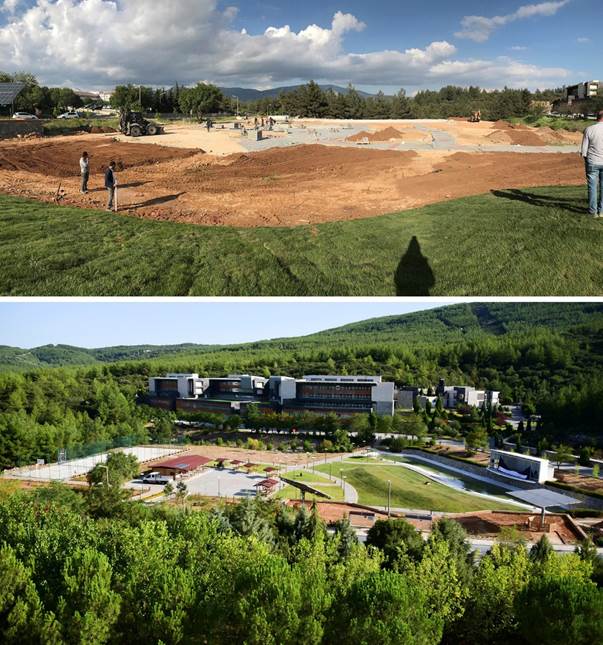
The project site is positioned in one of the valleys, of which the front façade of the Engineering Faculty Building, located at the south end of the university campus, is facing. As the main transportation artery providing basic access to the campus buildings passes over the valley, a part of the valley remained in the north of the main transportation artery and some in the south of the respective artery. Within the scope of the adopted transect approach, in order to gradually integrate this valley area with the built environment, the section to the north of the main transportation artery was previously designed as a recreational area open to the use of students and university staff. In this section, the valley floor was transformed into a small pond by employing, again, an ecological and sustainable design approach. The continuation of the water element previously designed at the northern part of the main transportation artery in the valley floor has also been adopted as a design approach for the project area remaining at the southern part of the main transportation artery. Thus, the rocky valley floors revealed by the hydrology and natural topography of the area are symbolized by the water element, and the natural formations and traces provided by the geography are emphasized by preserving them. In Figure 5, the implementation process of the project is exposed step by step via the satellite photographs taken on different dates.
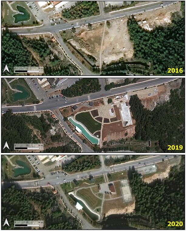
Source: Authors’ (2021) elaboration based on Google Earth photos
Figure 5: Satellite photographs from different years and the continuity of water element
Geddes introduced the concept of ‘civic survey’, a kind of socioecological process of analysis that must be applied before planning in order to understand the physical, social and symbolic landscape of the natural environment (Han, 2021). Therefore, the survey-analysisdesign (SAD) method, in which Geddes considers ecology as a metaphor on the one hand and a value to be prioritized on the other, is used in the project. According to Geddes (1915), a full survey and analysis are the first steps in plan-making, and his SAD method of design and planning does not consider city planning solely as a technical exercise. The SAD method, which is also known as SAP - survey, analyse, plan (Mualam, 2017), aims to offer comprehensive and inclusive solutions through the potentials offered by the environment, rather than choosing easy and direct solutions.
Influenced by Geddes, Mcharg (2006) advocates the necessity of considering the potentials offered by nature and the necessary restrictive conditions rather than arbitrary design. He characterizes ignorance of natural processes as folly or criminal negligence but at the same time he emphasizes the significance of skill:
Surely knowledge needs skill to give form and significance to our landscapes and our adaptations. Surely skill needs knowledge just as a solver needs a problem (…) art and science, skill and knowledge, ecology and design and planning should unite (McHarg, 2006, pp. 380-381).
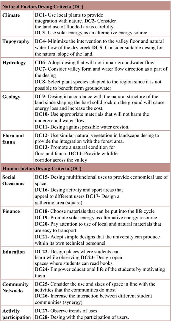
In this context, in the design process of the project area, some natural factors such as climate, topographical data, natural formations, conditions offered by the geography were surveyed and analysed with human factors such as social and economic inputs and evaluated in terms of opportunities and constraints they presented. According to survey and analysis, some design criteria (DC) were determined as given in Table 1.
Natural Factors
Climate: The province of Mugla, where the university and project area are located, is under the influence of the Mediterranean climate. The summer months are dry and the winter months are very rainy. Annual mean temperature is 14,9 oC. While the maximum mean temperature is 26 oC in July, the minimum mean temperature is 5,4 oC in January. The climate is very favourable for the growth of plants. Thanks to the abundant rainfall in winter and spring, there is a strong natural vegetation. However, the lack of rain in summer days can cause short-term drought. Mugla is one of the first two cities with the highest rainfall in Turkey. The average precipitation alters between 600-1200 mm. Heavy rains often turn into floods, especially in the valleys. The average sunshine duration is 3,040 hours/ year. Since the sunbathing period is quite long, it is possible to benefit from solar energy.
Topography: The university campus is located on a very sloping land. The highest point is 810m and the lowest point is 615m. Due to the high altitude of the university despite its climatic characteristics, a natural coolness occurs in summer nights. There is a dry stream bed and valley floor in the project area. The highest point of the valley is 709m and the lowest is 701m. Due to the slope of the valley floor, there is a significant amount of rain water flow in winter. In the area outside the valley floor of the project area, the slope is low and has suitable habitability.
Hydrology: In a significant part of the project area, there is a valley floor where a dry stream flows from the hilly area to the polje within the University campus. Groundwater flow rate increases in winter months due to heavy rains. The valley floor and the stream bed together with the vegetation create a cool microclimate. Due to the irregularity of the precipitation regime and the presence of permeable limestone rocks, the project area is very poor in terms of surface water resources. In addition, benefiting from deep underground water is limited.
Geology: The area has permeable rocky structure. The presence of the rocky structure provides a solid ground against the earthquake risk however, porosity causes water leakage. The project area has red-brown Mediterranean soil. Red brown Mediterranean soils are calcareous. The soil reaction is neutral or slightly alkaline. The land is characterized by shallow depth of soil (5020cm) with a slope of %6-12. The land has medium water erosion risk.
Flora and fauna: The university campus was established in an area where forest and maquis vegetation coexist. There are native species such as red pine, holly oak and juniper. There are groves of red pine trees around the project area that naturally creates a microclimatic effect. The forest vegetation around the project area supports the filtering of the rain water flowing at the bottom of the valley. Many bird species, foxes, wild boars, turtles, snakes and reptiles are naturally found in the forest and maquis texture. At the same time, campus paws protected and nurtured by the university use the project area. The fauna living in the forest vegetation near the project area constitutes a natural habitat.
Human Factors
Social Occasions: The project area was used as irregular parking lot, as it has remained idle for many years. However, pedestrians were uncomfortable with this situation. At the same time, vehicles harmed the natural environment and soil. Students need activity and sports areas on the university campus. Due to the lack of social activity areas on the campus, students spend much of their spare time in Kotekli, which became studentpopulated neighbourhood. The university should create a multifunctional open space for students to organize social occasions. This area will provide socialization that allows students to learn by observing. The fact that the project area is located in a central location within the campus provides the feature of being a gathering area. The location of the area in the transition zone from the natural environment to the built environment keeps the potential of creating an ecologically sensitive space.
Finance: MSKU is a public university. The university campus is entirely in the public domain and the projects are made entirely for the public good. University funding is provided by state taxes. Since a significant portion of the university’s budget is spent on the maintenance and repair of existing educational buildings, limited budgets are used in the design of open spaces. The project area is not among the compulsory expenses of the university. There are not enough financial resources for landscaping applications. The existence of engineers and technicians with expertise in different construction fields in the Construction Works Technical Department of the University, the existence of Faculties of Architecture and Engineering and the existence of Wood and Iron Works Workshops in MSKU are important labour resources for the realization of spatial projects.
Education: On the main campus, there are 14 faculties, 4 institutes, 18 research and application centres. The number of students on the main campus is 23574. The project area has potential to increase the quality of educational life. The natural environment in the project area has the potential to develop learning skills to be environmentally friendly. However, there is weak educational motivation among students.
Community Networks: There are 150 communities defined by their interests that organize student activities in MSKU. The project area has the potential to be used by a wide variety of communities and users however, lack of communication between the different student communities is one of the constraints.
Activity participation: The university has limited space for hobby and leisure activities. Although the students are eager to participate in all leisure activities, there is a weak level of participation in decision-making.
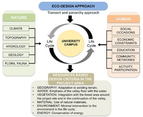
Overall, during the design process, adaptation to the existing land, emphasis of the valley floor with the water element, integration with the forest area around the project site and continuation of the valley, contribution to sustainability with the use of natural materials, minimal intervention to the environment in the life cycle, conservation of energy and quality of life have been adopted as the basic design criteria (Figure 6). Under the guidance of these general criteria, it is assumed that the pattern of human-nature interaction will be characterized by the operationalization of transect and panarchy approach for the formation of a site of ‘cloister’ in terms of creation of a place of contemplation, meditation, and imagination.
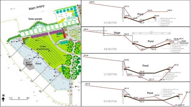
Photovoltaic solar panels, located on the northern side of the project site, have been used to provide the main campus with the electricity since 2013 and contributing to the establishment of a sustainable life system on the campus. The area where the solar panels are located has been designed as part of the project site with the arrangements in the landscape. The project area has been designed in such a way that it consists of structural design elements such as a pond, grass amphitheatreviewing terrace, multifunctional stage, cafeteria square, pergolas, tennis court, basketball court and parking lot area in order to create a sustainable space that students can use for different social activities (Figure 7). The natural pedestrian route created by the circulation of the students, the existing stone wall created by the level difference in the valley and the existing walls around the solar panels are considered as important traces for the design of the project area. While the pedestrian route can actually be considered as a tacit form of students’ participation into the project, recognition of existing walls in the project area as inputs can be considered as a continuity in the expertise involved in the project area.
Components and implementation of the project
The components of the project can be grouped under four parts. The first one is the pond, viewing terrace and stage. It is at the heart of the project that is designed adaptive to the valley floor. It represents the most immense crystallization of cloister in the project in terms of functions assigned to it. Three other components are seamlessly articulated to this basic component. These components are the square, the sports fields and the functional component of the activity area.
Pond, viewing terrace and stage
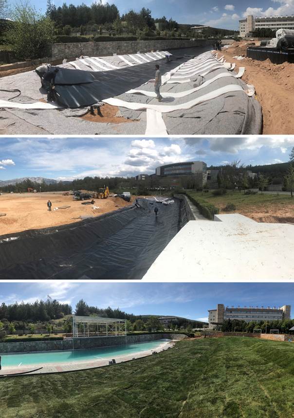
The design of the pond, the viewing terrace and the stage, which are the key design elements that make up the Outdoor Cinema, were carried out by taking into account the potentials and constraints offered by the natural endowments. The pond, viewing terrace and stage located in the western part of the project site, include the valley floor having a very sloppy water flow bed. During the construction phase of the building of the Faculty of Engineering, one side of this water flow bed was limited by a natural stone masonry wall with a height of approximately 4 meters due to the construction of a road over the valley for the creation of a connection from the main transportation artery of the Campus to the Faculty Building.
A pond having a linear form was designed both to ensure the continuity of the pond in the upper part of the valley to the north of the main transportation artery of the campus, and also to symbolize the flow at the base of the valley (Figure 8). During the application phase, concrete burrs were laid on the bottom of the pond area to ensure the continuity of the natural flow, in order not to disturb the flow of groundwater and natural drainage, which increases with heavy rains in winter time. Due to the very permeable and porous rock structure of the natural ground, the fill soil whose size and mechanical properties were determined according to the requirement of the site, was placed on the ground of the pond area by compacting. The pond area with the designed crosssection features was created by leveling this compacted filling ground.
Geosynthetic felts and geosynthetic gas drains placed on the created pond area in a controlled manner are covered with a linear low-density polyethylene (LLPDE) membrane (Figure 9 a and b). Small-sized stones produced from Mugla marble, which is naturally found in Mugla province, were placed on the geosynthetic felt, which was laid again on top of the membrane, for, on the one hand, the creation of weight on the membrane, and on the other hand, the protection of the geosynthetic membrane. Although at the initial phase of construction, the use of white Mugla marble pieces had created an artificial impression; in time, the colour of the water got natural because of the moss.
A viewing terrace for 700 people was created with a grass amphitheatre rising from the pond on the valley floor. While the grass amphitheatre was being created, the excavation resulting from the levelling of the land was collected and compacted on the floor of the terrace area. While the water element symbolizes the valley floor throughout the Campus, it also functions as a boundary element between the stage and the viewing terrace.
Taking advantage of the height offered by the existing stone wall on the opposite side of the viewing terrace, a steel construction stage about 16 meters long and 6 meters wide was designed on top of it. The outdoor acoustic environment, which is a hidden but important part of the landscape character, was also taken into account in the design of the stage. Sounds, which are always ignored in physical planning but are the source of human sensory experience, are expected to be in harmony with visual design. A landscape plan or design that focuses on acoustic experiences will enable the acquisition of acoustic qualities that support daily life and thus contribute to ecological sustainability. In this context, Geddes’ survey-analysis-design process creates incremental planning that sets the frameworks for the soundscape of the future (Hedfors, 2003). For the stage design in the project area, an arrangement that provides a gradual transition to planned human activities without disturbing the existing soundscape of the outdoor living environment of which plants and animals are naturally a part has been formulated. Therefore, the stage is designed behind the water element with controlled access to minimize the noise and movement associated with unnecessary human activities. The stage orientation is towards the grass viewing terrace facing northwest. Thus, for the outdoor performances, while the hilly topography behind the stage shades the audience, those on stage will not be dazzled by the evening light. The stage is designed with a convex opening that will allow the sound inside to reach the grass amphitheatre with maximum efficiency.
Filtered water fountains, which are placed in the pond and also providing recirculation of water, emphasize the hydrological features of the nature of the land in the project area, and at the same time, on the one hand, they stimulate the auditory sense of the water element in the soundscape, and on the other hand, they create a feeling of coolness in a place with hot climate features such as Mugla.
The viewing terrace has been established as a completely grass area in the form of terraces consisting of approximately 2-3 meters wide and 1 meter high so that the scene-stage can be seen completely from every angle (Figure 9 c). The viewing terrace not only creates the seating areas of the outdoor cinema, but also allows different activities and increases the amount of green space on the Campus thanks to the natural grass used as the covering material for the terrace.
Source: Authors (2019)
Figure 9: (a and b) Construction phase of the pond on the valley floor, and (c) installation phase of the stage and the grass amphitheatre
Since the highest point of the stage and viewing terrace is approximately 4 meters above the project site, it creates panoramic views of the entire project area. Thus, together with the viewing terrace on one side of the pond, the stage on the other side, the border element on the valley floor, and the forest area, it creates a ‘spectacular’ area on its own by offering different perspectives as a whole.
Square
The project site also contains a route via which students reach the Faculty of Engineering on foot from the main road artery that circles the campus. A square that can be a gathering place for students to socialize and that also opens up to the pond was designed in the center of the project area (Figure 10 a). The square is a nodal point where the routes from the Faculty of Engineering, the Faculty of Science, the Faculty of Economics and Administrative Sciences come together. One of the basic principles in the design of the project site is the selection of sustainable materials. Moughtin & Shirley (2005; 32) classify building materials according to their energy content and argue that which building materials combination is environmentally friendly should be evaluated among competing factors such as being taken from local source, the energy content, the intensity of building, the simplicity of form, the transportation expenses and the process of refinement.
All around the square, there are pergolas and a cafeteria that define the form of the viewing terrace and the square itself (Figure 10 b). These pergolas and the cafeteria were made of completely natural pinewood material by the University’s Wood Workshop. According to classification of Moughtin & Shirley (2005, p. 32), wood is low energy material with a 0,1 kWh/kg. In the project area, because of the pinewood material is indigenous and from a local source - taken from the pine trees of Aegean Region of Turkey where Mugla Province is located - and the amount of energy used in the manufacture is low, this material contributes to ecological and economic sustainability.
The cafeteria building was designed in a simple, singlestorey form that would be a means of defining the square. At the same time, the solar panels placed on the roof of the cafe allow the building to generate its own energy with an intention for self-sufficiency having origins in economic and ecological sustainability. It is important to emphasize that these panels were transported from a disclosed facility of the university and constitute another good example of re-use. Each of these panels produced by a company in Turkey in 2020 generates 270W. 1 kW of the generated energy is used for a refrigerator (used in the cafeteria) and electronic cash register. If the system works with a grid connection, it can produce 1500 kWh of energy annually. Existing solar trackers monitoring the sun in the project area were made in Germany. Although 1908kWh/kWp energy is produced by them annually if the system monitors the sun, the annually generated energy decreases to 1459 kWh/kWp if the trackers have a fixed tilt angle (Eke & Senturk, 2012).
Sports fields
In the project, which started out with the aim of designing a ‘place’ for the students who can enjoy different and various activities, a single basket court and tennis court were also designed for the inclusion of some sportive activities. Economic constraints and the sustainable design approach that aims to reuse materials in their life cycle have been effective in the implementation of sports fields. For this reason, the heating pipes that became idle as a result of the conversion of the University’s heating system to natural gas have been reintroduced into the life cycle by using them as the vertical and horizontal carrier system of the wire fences surrounding the basketball and tennis courts. Viewing areas have been created on the edge of the sports fields with the installation of the seating benches, again made of natural pinewood material.
Sports fields were designed in the project’s eastern part where the campus started to merge with the forest area and formed the eastern border of the project. Thus, the project site composed of the Outdoor Activity Area containing a viewing terrace together with the pond and stage in the west, the square together with the cafeteria in the middle, and the sports fields in the east has been transformed into a place that allows the University students to perform various physical and social activities (Figure 10 b).
Activity area
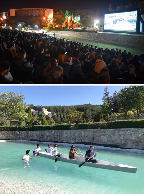
Since its completion, the project area has been used for a wide variety of social, cultural and educational activities as intended. At the forefront of these activities is outdoor cinema screenings. During September and October 2019, Outdoor Cinema Activities were held in the project area with a movie every week1, which attracted great interest from the University students (Figure 11 a)2. During the pandemic, it has met the need for open green space for university staff accommodating on campus and students in dormitories. After the pandemic, the active use of the area has continued in 2022 with movie screening3 and cultural activities such as theatrical performance of Karagöz and Hacivat, lead characters of the traditional Turkish shadow play.4
In addition, the buoyancy test of the concrete canoe produced by Civil Engineering students for the Concrete Canoe Competition in 2019 was carried out for the first time in the newly completed pond area (Figure 11 b)5. The Outdoor Activity Area has also served as a show area for sports activities such as pilates and yoga performed with multi-participants, concerts, theatre, talks, etc. organized by students.
Concluding remarks
The Outdoor Cinema and Activity Area Project, implemented in the Main Campus of Mugla Sitki Koçman University, have revitalized a 10-decare land, which was idle for many years in the campus, by a landscaping prepared with an ecological and sustainable design approach. At the beginning of the design process, the University campus has been conceptualized as a part of a social-ecological system in terms of its geographical location and relationship with other settlements, and it has been accepted that a framework of interdependent nature and human interaction that develops at different scales and times operates within the panarchy, which is a set of intertwined adaptive cycles. Building on top of the ideas formulated by Geddes, the cross-fertilization of these ideas with more recent design concepts such as transect provided us with a framework to operationalize them in a coherent way.
Invasion of the pond by frogs is illustrative of one of the adaptive cycles intended in the project area. Another positive aspect of this cycle is the fact that in the hot summer days, the pond function as a source of basic nutrition (water) for the fauna on the campus and nearby area. The use of wood in the project is another concrete example for the consideration devoted to the operationalization of the adaptive cycles. It is known that wood is one of the best reusable and bio-destructible materials.
In the design of the project area, based on the fact that ecological, hydrological, climatic, social and economic conditions create a ‘life’ throughout the campus, it has been argued that these conditions should be adequately understood and adapted to the nature in order to ensure sustainability. Geddes’ survey-analysis-design method was adopted in the design process of the project area, and all the features of nature and users were taken as inputs in such a way that the design was finalized in interaction with the analysis process. In this context, while the functions were determined by examining their compatibility with the environment, implementation was started in line with the objectives of the use of natural materials and the conservation of energy in its life cycle.
Active use of the area by the students as a place of contemplation, meditation (such as pilates and yoga) and imagination (such as theatrical performances) reveal its characteristics as a site of ‘cloister’ which was the basic aim of the project. MSKU outdoor cinema and activity area has become so popular among the students that it was named ‘moonlight square’ with a voting process after the suggestions from students which is in accordance with the social participation dimension of the project design cycle. Departing from an empathy for the students who are active users of the area, we can argue that the efforts made for the emotional engagement seems to be followed by not only a synthesis of different ideas for the realization of the project in terms of intellectual engagement, but also cooperative engagement in terms of active participation of the students in naming the area. From our point of view, ‘moonlight’ reflects an emotional motivation characterized by not only meditation, but also imagination. An understanding of contemplation seems to be also embedded in this particular name in terms of a search for truth in the dark.

