


 Español (pdf)
 Articulo en XML
 Referencias del artículo
 Enviar articulo por email
 Citado por SciELO
  Similares en
SciELO
Similares en
SciELO 
 Permalink
1. Introduction: Rethinking Urban Space
The technoscientific and theoretical changes fostered during World War II shifted the conception of the city from a bounded territory whose structure, shape and function is determined by culture and polity, to a topology that evolves according to the complex network of relations it contains. In a recent article, Michael Batty has noted the possible transformations that could emerge from an unexpected event, concretely the COVID-19 pandemic and how these challenge the compact and functional idea of the city (Batty, 2020, p. 549). Batty notes the changes in transportation and work habits, such as avoiding crowded public transport and working from home. But the pandemic has also shined a light on other issues with our current urban planning model. For example, the restriction of international mobility and the difficulties in stopping the virus whilst sustaining economic growth, evinces the global network of connections and dependencies maintaining urban way of life and prompts us to rethink current globalism. Furthermore, this zoonosis has highlighted the depletion of other species’ habitats as a consequence of uncontrolled urban growth (Ostfeld, 2017), which calls for sustainable cities planned beyond the imperative needs of efficiency and functionality. Still, the isolation during lockdown has caused an increase in psychological problems, especially among the most vulnerable members of society -older people and children- and caused us to focus more attention on the need to promote networks of care that favour a more social city. Finally, the increase in network communications and services (for example, the pandemic has accelerated digital transformation in Spain by seven years) (Cueto García, 2020) has revealed an urgent need to develop participative and transparent technologies and policies to protect people from privacy intrusions and biased algorithms.
The pandemic has highlighted the weak spots of our urban space, highlighting the need to examine the recent developments in urban planning and management, especially following the rise in Big Data and ubiquitous technologies. From its inception, the application of ubiquitous technologies to urban space has swung between top-down projects and participative initiatives. I reviewed some of these proposals as part of my doctoral research and looked at how they have altered the practised, conceived, and lived space described by Lefebvre (Álvaro, 2016). In the present article, I will review and discuss some of the procedures and theories presented in my previous research and relate them to new proposals and concepts. The aim is to analyse
the ongoing transformations of urban space in order to criticise its problems and unveil its potential for building an open urban space able to adapt to change, sustain networks of care, and foster more equitable relations with other species. Guided by this aim, this article studies the evolution of the postdigital city, namely the consideration of the potential realisation of urban space after the implementation of technological mediations.
Lefebvre is one of the most prominent names in New Urbanism, a movement that emerged during the decades following World War II and which is based upon the new understanding of space laid out using modern mathematics and complex systems theory. He proposed the Unitary Theory of Space as a reaction to the homogenisation and fragmentation of modern space. The evolution of hierarchised space -in which social order establishes a fixed position for every entity over the Cartesian coordinates system- towards mechanistic space evacuates public life from the streets, which are transformed into corridors to transport workers and merchandise of the industrial system. This spatial barbarism subdues bodies, ignores anthropologically funded needs and dissolves historical places. In looking for alternatives, Lefebvre proposed considering space as intensive, not a fixed grid, but as a manifold, always able to hold new relations and evolve towards the realisation of new possibilities. The intensive space substitutes the science of the city -the programmatic realisation of a previously defined object- for experimental pragmatics, in which the urban space becomes the act and oeuvre of complex relations that can only be realised on the ground through the action of groups with a revolutionary initiative. (Lefebvre, 2000, p. 472). The Unitary Theory of Space reunites art, technique, and knowledge to analyse this pragmatics and its capacity to fulfil the Right to the City, or in other words, citizens’ creative involvement in the production of space (Lefebvre, 2000b, p. 154).
The implementation of computing technologies has subdued the city to new pragmatics: mechanistic fragmented and hierarchised space is becoming emergent and continuous. Since the turn of the century, the urban space has mutated under a new technologically mediated functionalism. This means our inhabited space has been superimposed with platforms that form part of a global and highly relational system, which force it to submit to the logic of computer binarism and give way to new forms of domination (Zuboff, 2008, Srnicek, 2016, Dijck et al., 2018). However, the embedding of networked objects also intensifies space, its capacity for retrieving and processing data, facilitating new opportunities for emergent and participative production (de Lange & de Waal, 2019; Glas et al., 2019). In this text, the Postdigital denominates a critical approach to the technologies performing our space. This critical analysis will also consider the urbanism and media theories that have been linked to this phenomenon since the end of the 20th century. Among them are predictive geography (Batty, 2013), the description of the data-driven networked urbanism (Kitchin, 2017), the participation of urban informatics (Foth, 2009) and the non-representational theory of space (Thrift & French, 2002).
2. Methods: PostDigital and the Unitarian Theory of Space
This article proposes postdigital as a concept that allows for a critical approach to the changes that have affected the planning, management, and perception of urban space, since the application of ubiquitous technologies. Once defined, I will analyse the postdigital space by applying Lefebvre’s unitary theory and pragmatics. With this aim, in the methodology section, I will introduce Lefebvre’s Unitary Theory of Space and the tripartite consideration of space as the practised, the conceived, and the lived. Here, I will also introduce theories concerning digital architectural design and ubiquitous computing that contribute to the definition of the postdigital concept. When presenting my results, I will offer my analysis of the post-digital city, addressing the changes affecting the practised, conceived, and lived space that have been demonstrated in a selection of projects that reveal the problems and possibilities of the technologically mediated space. In the final section, I will discuss the need to develop new concepts that rethink the application of digital technologies and envision an affective and more-than-human space in the Anthropocene.
2.2. Ubicom and PostDigital
Digital humanists proposed the term ‘postdigital’ to refer to how digital mediations are altering access to knowledge (Berry, 2015). This concept was subsequently expanded and used in other fields of research, notably cultural theory, to denote a series of projects that take a critical approach to technological mediations and their issues (Bishop et al., 2017). From these proposals, we can establish the postdigital as a critical approach shared by various perspectives, arising from the humanities and sociological research, that examine the changes produced in our environment and daily lives following the spread of ubiquitous computing. In the practice of art and design, this critical approach will also lead to the proposal of strategies and creative projects that aim to unveil and disrupt the systems that operate in our environment, as well as propose alternative uses (Álvaro, 2016).
Mark Weiser defined ubiquitous computing in 1991 as an upgrade in the dissemination of computation based on a new interaction paradigm. In it, the dissemination of networked objects with computational capacities displaces human-machine interaction from simulated environments projected onto screens, to the richness of the physical world (Weiser, 1991). The embedding of computation in the devices we interact with every day has fostered the hype of the IoT (Internet of Things) and the consequential Big Data revolution. Furthermore, the availability of Big Data has boosted advances in AI (artificial intelligence) based on machine learning. Nowadays, ubiquitous computing has become intelligent and has increased its capacity for surveillance and prediction, while also raising new concerns and possibilities.
In 1997, Batty foresaw the embedment of computing technologies into urban space and the shift of focus it would entail, from using computers to understanding and scientifically analyse space, to their use in space management and planning (Batty, 1997). Nowadays, the algorithmic power of computers facilitates financial transactions, traffic monitoring and transportation flows in real-time, and mediates the perception of our space through interfaces in order to navigate geographical data The capacities and availability of the AI-based services offered by big companies like Google or Amazon -now commonplace- have surpassed the projects Batty envisaged and driven forward the realisation of Weiser’s dream: everyday life assisted by the devices of a pervasive system able to predict our behaviour and needs. Weiser projected a space in which humans can focus on what matters, while invisible machines solve the small practical matters of everyday life, increasing efficiency and minimising error. However, this promising scenario is not without its pitfalls and concerns. The realisation of ubiquitous computing involves the scattering of new sentient agents with their own timelines and modes of intervention that enter into infrastructural arrangements, generating new urban forms and political economies (Amin & Thrift, 2016).
2.3. Lefebvre and the Unitary Theory of Space
Lefebvre characterizes space as social production, a collective process that cannot be explained by the traditional epistemologies focusing on the individual (Lefebvre, 2000, p. 35). The practices that codify, plan and construct our cities do not result from an individually predefined design, but emerge meshed in pragmatics and involve an ensemble of relationships between multiple agents. In this regard, a complex production emerges and evolves through time, as the informational space and the communication channels facilitated by technologies transform. The flow of information and communication shapes different city typologies, from feudal regimes shaping the closed city, to advanced capitalism and the layout of abstract space.
Lefebvre conceived the Unitary Theory of Space to account for the ontogenesis of this complex space. It involves the analysis from three standpoints that exist simultaneously: the space of practice -the daily-perceived environment where our actions take place, according to a codified system of norms-; the conceived space -the theories and forms of knowledge that shape production and management-; and finally, the lived space, or space of representation, from where the codes that shape our culture arise, the space performed by the rhythms of the bodies inhabiting it, and where certain forms of art can emerge. The interaction between these three fields challenges the codified space, which evolves according to the new rhythms of the lived space (Lefebvre, 2000, p. 51).
The analysis of the postdigital city from the three standpoints proposed by Lefebvre has a twofold objective. First, it aims to introduce changes to the urban space following the dissemination of non-human agents and the pervasiveness of data processing, underlining its issues and concerns; and second, to present strategies developed by different collectives to foster participation and disrupt the obfuscated working of technological mediation. The questions guiding this analysis are: How has the realization of utopian technologies for simulation and prediction affected the practice of urban space? How are the codes and protocols -now updated by intelligent machines- that determine our behaviour changing the practised space? Which conceived space is laying out the new cartography modelled in real-time? To what extent are users able to appropriate the lived space after becoming augmented bodies capable of leaping between multiple spaces and regimes of proximity? Finally, how do the paradigms related to ubiquitous computing relate to the Anthropocene, and which new design strategies are arising towards a more-than-human city?
3. Results: Practiced, Conceived and Lived PostDigtal Space
3.1. The Practiced Space
Computing processes are territorialising the practiced space. Software is meshing to form powerful assemblages such as transportation systems and those supplying resources, as well as more quotidian uses related to personal communication and entertainment. As a result, computerised processes and artificial agents act upon the ecology of our dwellings and change social, economic, and spatial life.
The aforementioned systems lead to the data-driven networked urbanism that characterises the smart city paradigm (Kitchin et al., 2016). Smart urbanism postulates the city as a complex evolutive system composed of multiple linked layers. First, there is the sensory layer. This layer opens us communication channels between citizens and the territory by employing frameworks that receive and send data. This matrix of algorithmic perception permanently registers citizens’ activity, gathering data from sensors, cameras, smartphones, and social web interfaces. Terms like co-surveillance, codesign, civic hacking, crowdsourcing, and participatory sensing designate this bottom-up approach, in which citizens become another data source feeding the system. In addition, there are multiple layers of processing and storage, forming a subterranean cloud architecture that enables real-time management. It includes the levels specifying applications aimed at particular services and integration and control platforms that allow us to manage the whole system and increase its capacity for generative automation (Bratton, 2016).
The automation of our practised space is not happening without concerns. The smart city paradigm is a form of corporative governance that relinquishes social space to the interests of a handful of big companies (Hollands, 2015, Söderström, et al., 2014). They also expose citizens to the pitfalls of Big Data (Kitchin, 2017) and new forms of surveillance and control of advanced capitalism (Klauser & Söderström, 2016). It is also important to stress the effect these systems have on our behaviour. Ubiquitous computing determines our affordances in an operation that Marvin and Graham named ‘software sorting’ (Marvin & Graham, 2005). Our mobility across the physical space meshes with systems such as the routing of merchandise and passengers in airports or electronic ticketing systems -based on biometrics and traceable embedded circuits-, geographical information systems (GIS) -filtering our preferences accordingly to our consumer habits-, and surveillance systems -implementing facial and gesture recognition-. These systems manage our access to space through algorithms, which highlights social inequalities and facilitates new forms of political control. In addition, there are problems linked to the interaction paradigm that sustains ubiquitous computing: the systems of ubiquitous computing act in the background, out of range of our perception, thus constituting what Thrift calls the ‘technological unconscious’ (Thrift & French, 2002). Also, Greenfield (2006) points to the loss of agency produced when we engage with them. These intelligent systems become imperceptible assistants that disable our ability to orientate ourselves and interact within the space without the need for continuous monitoring and guidance. The last issue emerges from the recursivity of intelligent systems. Despite the emergence of the integrated technological whole that manages our cities, these systems work by applying already implemented solutions to anticipated problems. The artificially intelligent systems empowering city management work by extracting patterns from recursive cycles of recognition and verification that are then used to foresee the possible outcomes of any situation. Automated urbanism implements this capacity towards pre-emptive control, which results in a pre-programmed space and the closure of the diversity and creative evolution that characterises multitudinous urbs.
The smart city paradigm has been unevenly applied. Masdar, initiated in 2008 in Abu Dhabi, and Songdo, built on a new portion of land on the coast of South Korea, are examples of working smart cities constructed from scratch. However, there are also failed examples such as Smart Puebla in Mexico or Toronto’s Quayside -the Google smart city aimed to harbour the Canadian headquarters of the technological giant and a betatesting lab for urban management solutions (Jaffe, 2019). Sidewalk Labs discontinued Toronto’s Quayside in May 2020 after it was criticised as technology for technology’s sake. More importantly, citizens have shown discontent for the erasure of their inhabited space due to the imposition of functional and corporative culture. These examples are forcing us to rethink this paradigm. On the one hand, companies stop focusing on global solutions that address the entire workings of the city and instead focus on fabricating dedicated solutions, such as carsharing and navigation apps. On the other hand, city planners and governments are turning their attention to urban planning instead of technological solutionism. The smart city could not be accomplished by technology, because it requires attention to specific cultures, the engagement of the population and the introduction of adequate policies. Despite this, political problems are on the rise due to the centralisation of services and infrastructures in a few corporate giants, mainly located in the United States. Small and medium countries cannot compete in technological innovation and are dependent on big companies. This loss of digital sovereignty is aggravated when citizens submit their data to racially and gender-biased applications which could influence their behaviour, thus leading to technological colonialism (Ávila Pinto, 2018).
The practiced space concerns the codification of space: the laws, conventions, methodologies, and material resources determining the use and construction of space. (Lefebvre, 2000, p. 42). In contrast to the systems of control implemented in smart cities, computing technologies could also intensify space, laying out new possibilities for its design. Computer space which abstracts architectonic morphologies into manipulable data intensifies the forms in which these data can be rendered. In addition, embedding sensors into buildings means we can track the multiple flows traversing them, and therefore perceive buildings as evolving processes rather than immutable objects, the result of navigations across a landscape of controversial data (Latour & Yaneva, 2008). Dynamic temporal processes, negotiations between different uses, materials, economic restrictions, and regulatory policies determine the placement and morphology of buildings and their transformation over time. Arch-OS forms part of the i-DAT operating system project developed at Plymouth University, consisting of a software-hardware system that makes the data-space of the building tangible. This set of tools collects data from the energy management systems, computer and communication networks, the flow of people’s social interactions, noise levels and environmental conditions. Afterwards, these data are deployed in visualisation and sonification systems, linking the building to its social use. This project overlays a space where the perception of the constructed place shifts from the permanence, separation, and ordering of space to an intensive space of relations.
Furthermore, the conjunction of computer design with ubiquitous computing allows us to develop responsive architecture able to adapt to the environment and react to social interactions. Computer-aided architectonic design can develop new processes of form-finding, in which software is an active component. Parametric design is an example in which software modulates heterogeneous data into a continuous function. Parameters are variables related to other variables, ranges of probable values that link variables in relationships, which variation could change the resulting spatial form. Parameters work as nexus or Spatio-temporal events, the addition of new variables resulting in the evolutionary processing of the design. Ultimately, the goal of the parametric design is deep relationality, the real-time integration of the evolving variables of a built environment inside software systems able to create scenarios by responding to or preadapting data (Parisi, 2013).
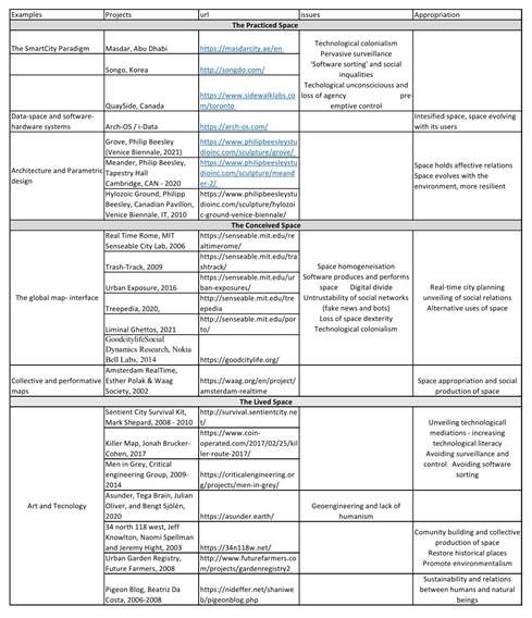
Using the parametric design, conjointly sensorbased systems assisted by machine learning, and experimentation with new materials, Philip Beesley and the Living Architecture System Group developed responsive spaces where architectural constructs became performative instruments. Hylozoic Ground, produced in 2010, consists of a forest of light interlinked structures which, equipped with sensors and mimicking the evolutionary movements of plants, breathes and reacts to the actions of the immersed audience. Meander, produced in 2019, is an ecosystem that emulates natural ecosystems. Its constituent elements pass data and signals back and forth and behave as an interconnected whole. The interlinking of many delicate parts results in a robust whole able to handle intense amounts of force. Finally, Grove, presented at the Venice Biennale in 2021 (Figure 1), is an example of responsible architecture inspired by the communion with plants. Grove creates an immersive environment of reactive and changing morphologies that substitutes the traditional idea of citizenship bounded by walls that shape the territories that divide us, with world-shared architecture based on dissipated natural forms that are resilient and self-regenerating.
Source: https://www.philipbeesleystudioinc.com/
Figure 1 Grove, Venice Biennale 2021 by Philip Beesley
In the aforementioned technologically-enabled projects, the emergence of unexpected evolutionary forms replaces control. Beesley’s architectural sculptures pursue emphatic feelings inside self-renovating metabolisms inspired by natural forms. The implemented innovations suggest ways for developing an urban future that can adapt and thrive in the unstable environmental conditions of climate change.
3.2. The Conceived Space
The conceived space has also mutated with the embedment of new technologies. In The Image of the City, Kevin Lynch explores how the distribution of landmarks in urban space creates a frame of reference for organising citizens’ experiences (Lynch, 1960). This mental image weaves together identities and urban structures in the deep texture of places. Lefebvre points to citizens’ use of space as a performance able to evolve this texture and defined rhythm analysis as the study of the rhythms started by the movements of citizens’ bodies, whose resonance produces meaning by linking space points with needs, purposes, and experiences (Lefebvre, 2000, p. 466). Nowadays, smartphones’ tracking-guidance systems have substituted this framing image with the global map, an interface composed by superposing switchable layers.
The digital map has become a space producer, which modulates the geographical territory into a homogenised space-time continuum, working at different scales. The digital rendering of geographical data links the Earth as a globe to the personalised space we access from our mobile phones.
Maps are not mimetic representations of an already existing territory, the geographical space, but the performance of this territory that employs a cascade of processes of inscriptions aimed at calculating its possible navigation (Latour et al., 2010). The current navigable map is an assemblage of complex processes of inscription: the digital processing of aerial and satellite images, the Global Positioning System (GPS), and the Geographical Information system (GIS) -a compound of related databases that assemble heterogeneous data and renders them as an interface. This technological complex geolocalises entities and events and overlaps them onto the base map in real-time, visualising the flows produced in our space at different scales.
One early example of this cartography was Real-Time Rome, developed by Carlo Ratti and his collaborators at the MIT Senseable City Lab (Ratti et al., 2006). This project, presented at the Venice Biennale in 2006, used data obtained from the localisation and tracking of phone users to create mobile landscapes, a graphic representation of the intensity of urban activities and their evolution through space and time. The large-scale data mapped onto heat maps were used for urban planning purposes, correlating people’s mobility with the availability of public transportation. The evolution of mobile communications, the multiplication of sensors distributed throughout the urban space, and the opendata movement, which has led local governments to publish their demographic and geographical data, has facilitated the elaboration of more complex maps. By modelling networks in which humans and non-humans appear to have complicated relationships with their environment, these maps allow us to address different questions related to urban space management. In this regard, the projects elaborated at the Senseable City Lab demonstrate the development of different methodologies and inquiries. Trash-Track, developed in 2009, consists of RFID tags attached to waste and monitors the global network produced by waste treatment. Urban Exposure, 2016, uses environmental data and mobility data to quantify human exposure to air pollution (Nyhan et al., 2016). Treepedia, 2020, applies computer vision to Google Street View panoramas to measure the GVI (Green Visual Index), the canopy covers in cities understood as the amount of green perceived while walking down the street. Liminal Ghettos, 2021, charts density, social-economic diversity, and citizens’ mobility across Porto to determine how the pandemic has affected integration and segregation.
Another approach uses Big Data produced by social networks to explore the image of the city aggregated from multiple shared perceptions. One example is the GoodCityLife project developed by Daniele Quercia and his collaborators at the Social Dynamics Research, Nokia Bell Labs in Cambridge. GoodCityLife explores social data, not with the aim of developing smarter or more efficient cities, but with a view to making dwellers happier. Social media data is analysed using geotags and textual analysis to map the sensory and emotional layers of the city and develop applications like Happy Maps. This application guides users not across the most efficient route, but the most pleasant route.
Nowadays, the technologies behind the cited projects have been generalised and are now part of our daily lives. Services like Google Maps provide real-time traffic information and guide us through the most convenient route, while recording our daily journeys to recommend services and places. In addition, other services rely on geolocalisation to efficiently guide taxis, deliver food from our favourite restaurants, and facilitate carsharing. Geolocation-related services and research link our daily activities to non-humans in complex networks that empower the social production of space, but not without concern. First, social dynamics research assumes that data are seamlessly and equally produced across territories, overlooking the gaps in regions that are poorly connected (Aguilar, 2002). Another acritical assumption is the trustworthiness of social networks, a contested territory after the use of bots to manipulate public opinion (Álvaro, 2018). Finally, personal data belong to a few big companies, who exploit them for profit. In short, there is no object for the computational device to process without discrete encoding. The encoding process discards information, reducing differences and normalising places and people into sets of data points. In addition, faced with these maps, we lose our dexterity in interpreting city signs and our involvement in the places we are moving through. Once rendered in computer space, the texture of places is no longer the precipitate of experiential events, but the product of the relationship between databases. If our world is constantly connected and updated with real-time information tailored accordingly to our current position and needs, it becomes reduced and redundant, even if we believe we are managing it in our hands.
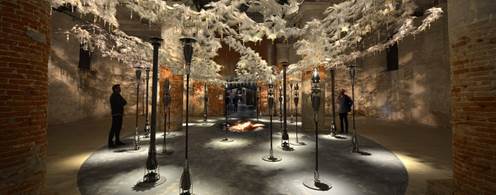
However, artists and collectives of engaged citizens can also appropriate the map for the social production of space. Digitally rendered maps can unveil and disrupt the hidden structures shaping our space. Furthermore, maps can serve as platforms for engaged collectives to meet. Esther Polak and Waag Society created Amsterdam Real-Time in 2002 (Figure 2). It consists of a group of volunteers that reports their movements across the city’s streets. An interface draws the data streams and shows not the planned territory, but the lived space.
3.3. The Lived Space
The space of representation is the lived space appropriated by citizens to accommodate their necessities and desires, and where art exercises its revolutionary activity towards the proposal of new futures (Lefebvre, 2000, p. 49). Artistic practice activates new collectives -assemblages of humans and non-humans- that use space in unexpected ways, activating the creative capacity of difference and the emergence of new possibilities from the virtual (Deleuze & Guattari, 2005). The architectonics produced by the appropriation of space is facing new challenges and possibilities since ubiquitous computing has allowed ever-connected citizens’ bodies to switch between multiple spaces and regimes of proximity. The performance of space effectuated by the rhythms started by the movement of bodies intensifies when they encounter the increased capacity of modulation of the non-humans engaged in computing processes.
Art appropriates the ubiquitous computing devices and emmeshes them into new assemblages of humans and non-humans. The communication that takes place within these assemblages starts new transductions, which disrupt and transform the space produced by the ‘technological unconscious’. First, we encounter projects that reveal the hidden mechanisms commanding our technologically mediated space, unveiling its capacity for surveillance and control. One example is the Sentient City Survival kit, developed by Mark Shepard between 2008 and 2010. It consists of gadgets aimed to avoid technological control in public spaces. Among them, the CCD-Me-Not Umbrella distorts its wearer’s image, evading tracking and the identification of citizens detected by surveillance cameras and computer vision. The Travel Mug dodges the tracking and profiling of internet users, building an alternative network. Finally, the Serendipitor is a navigation application to evade ‘software sorting’. The alternative map drives us away from our well-known and functional routes to increase serendipity or the probability of unexpected encounters, which could enrich our experience of the city. Another alternative navigation service is the Killer Map, produced by Jonah Brucker-Cohen and his collaborator in 2017. This map incorporates live public-domain crime data, driving users through the most dangerous public spaces, the invisible city that has developed outside the commercial and functional routes.
Artistic research also creates digital objects, which connect to the global communication system to disrupt its functioning and unveil surveillance and control. The works by Julian Oliver and the Critical Engineering Group are one example. Men in Grey, 2009-2014, combines the production of disruptive objects and performative street interventions. The group performed in public places dressed as white-collar workers and carrying an M.I.G. briefcase, which captures and manipulates chat sessions, webpages, and other data harvested from open wireless networks to show them on its display. By surveying network traffic and displaying its contents in the public space, the performance unveils users’ vulnerability in the face of government surveillance and big companies.
Over the past few years, Julian Oliver has extended his artistic practice to include the consideration of the Anthropocene and has produced assemblages that go beyond human-computer interaction to include environmental issues. Together with Tega Brain and Bengt Sjölén, they created Asunder in 2019. The project consists of a fictitious AI-based environment manager. A high-performance computer deploys a neural network to analyse live satellite, climate, geology biodiversity, topography population and social media data. It then uses this information to produce simulations of future scenarios in which geoengineering applications solve detected environmental problems. The non-humanbiased system proposes disturbing solutions -such as the relocation of entire cities- to attain a balance between natural resources, social justice, and the protection of endangered species.
The conjunction of the navigable map whit physical networked devices also can be a place of encounter for collectives of humans and non-humans engaged in space production. The map becomes a platform for sharing knowledge and storytelling that territorializes space beyond control and towards new possibilities. Collectively contributed maps address different issues while promoting alternative uses of the urban space. Among them, restoring the memory of places -such as 34 North 118 West by Jeff Knowlton, Naomi Spellman and Jeremy Hight-, promoting sustainability and community building -such as Garden Registry by Future Farmers-, and engaging citizens in environmental awareness efforts regarding climate and pollution control. Citizen science has become a trendy practice that involves harvesting the potential of crowdsourced data while increasing awareness about human involvement in environmental problems. In addition, this practice promotes the formation of new assemblages, which unveil the complex networks of humans and non-humans acting in our environment. Pigeonblog by Beatriz Da Costa built a network linking humans, technological devices, and pigeons that collaborate in order to obtain environmental data using miniature networked sensors (Figure 3). Da Costa and her team attached the sensors to pigeons, enabling them to send air-quality data back to a website. The project explored new resources for data obtention and highlighted the traditional and new collaborative relationship between humans and other inhabitants of the city.
In the projects analysed in this section, the applications and devices of ubiquitous computing are freed of preassigned goals and appear in their unpurposeful nakedness available for experimentation. This experimentation increases our literacy regarding technological mediums while making them appropriable, in that their components can be aimed at new forms of interaction with the setting, from which new capacities can emerge. Artists and designers confronted with the postdigital city are engaged in the creation of new things, procedures, and paradigms able to show the embodiment of technologies in everyday objects and the multiplication of agencies that result from them: agencies enabled by new interfaces but also unhidden by visualisations and disrupted by new connected devices. Space production becomes a collective creation where individuals are engaged in the setting up of relations in an unfolding process from where all the agents involved become redefined, and technology could become emancipatory.
4. Discussion and conclusions: More-than-human networks of Affect
The last upgrade of our technological milieu has laid out a space that abstracts all our reality to data modulated through a diagrammatic system taking shape in physical space as a multiplication of transducers. This space becomes a ‘Big Here and Long Now’ (Greenfield, 2006), where the technologies that began as observation, measurement, and surveillance technologies become design, transformation, and governance technologies. Furthermore, ubiquitous computing has evolved and widened its capabilities thanks to artificially intelligent applications and the availability of Big Data. Weiser’s human-centred vision, where computers work as imperceptible assistants, has been globalised towards becoming an ecological vision where humans are not the centre of interaction, but just another set of data points inside a whole machine of communicating nested systems. Nowadays, smart cities have shifted from denoting a city-building paradigm to referring to a set of applications that form part of the digitisation process driving the fourth industrial revolution. These digital applications automatise processes on a global scale until they produce a megastructure (Braton, 2016). This process alters all productive and social tasks such as labour, commerce, leisure, governance, all mediatised by applications that communicate among themselves. However, this radical mediation (Grusin, 2015) is not so globally, seamlessly or easily implemented. In the previous section, we showed that paradigms such as the smart city or the global map-interface offer solutions to increase the efficiency of the compact and functional city. However, the homogenisation processes of these paradigms also entail multiple social issues concerning sovereignty, equality, and human agency (see Table I). Lefebvre points out that the social space is a social production. Citizen’s bodies move across space, starting rhythms and processes of resonance, which defy the codified space. The space is not just a network of information but a multi-layered texture of experiences, practices and partial knowledge, always available to be appropriated and repurposed, its codes translated or rewritten. The art and technology projects discussed in the present article show that computer-mediated design can intensify space by building new morphologies, which, assisted by the transducers of ubiquitous computing, can defy the apparatus of the practised space and create architectures for an open and responsive city. These transducers, when joined together in a network, can disrupt the structures of surveillance and control and unveil their inner workings and pitfalls. In addition, maps could become a platform for shared storytelling and encounters, supporting networks of affection and care between humans and between humans and their environment. All these projects repurpose the technological structures shaping our dwelling spaces. They also create links between urban planning and other disciplines like sociological research, history, anthropology, economics and environmental studies.
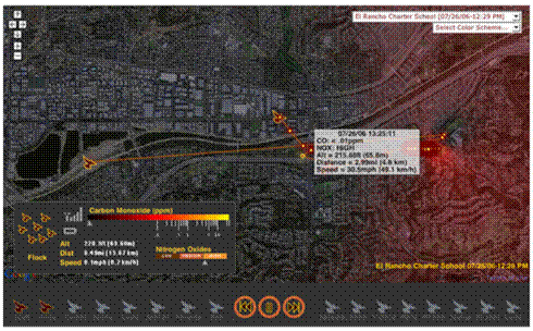
Source: https://nideffer.net/shaniweb/pigeonblog.php
Figure 3 Pigeon Blog Interface (pollution visualisation) by Beatriz da Costa
Events have the capacity of revealing the complex networks shaping our time. Pandemics develops across multiple human and non-human networks: the protein interactions of infection, the transport networks facilitating host-to-host transmission; global bio-surveillance and the regulations of governmental institutions; the medical-economic interactions of the pharmacological industry and medical research (Thacker, 2005). To the state of global crisis produced by COVID-19, we must add the communication networks that spread new regulations among the population, as well as misinformation and social responses that create public spaces to harbour rituals of mourning and local networks of solidarity. These networks go beyond the differentiated realms of nature and culture (Latour, 1993).
Lefebvre’s theory studies space across and beyond disciplines. However, it remains attached to the humanistic perspective, viewing humans as the privileged actors and space producers. However, postdigital research evinces how the production of space is not only the result of human social groups. The enactment of assemblages of humans with those nonhumans constituting our socio-technical environment is also producing space. Furthermore, some of the works listed above exhibit a shift in attitudes towards considering nature-cultures and including other living organisms as agents and producers of urban space. The projects by Philip Beesley point towards architecture as an open process in transformation, subjected to forces that go beyond the limits of the urban space and link to the global natural ecosystem. Julian Oliver and Tega Brain deploy the calculative power of AI to demonstrate the potential undesirable consequences when environmental justice is reduced to the calculation of risk and efficiency. Da Costa rebuilds relationships of codependence between companion species, the silenced others with whom we have always shared our dwellings. Nowadays, the urgency of environmental problems calls for the development of new approaches to city planning that go beyond sustainability and towards proposals of new ways of inhabiting the Earth. Proposals arise that consider the city as part of a broader ecology (Amin & Thrift, 2016), and that develop a more-than-human design that goes beyond energy efficiency and sees biodiversity and nature as constituents of the urban territory (Clarke et al., 2019; Houston et al., 2018; Loh et al., 2020). Computer technologies have great potential for cybernetic control and efficiency, but their modular architecture and disruptive power could also create lines of inventive connections between humans and non-humans. Sensing and computing the environment beyond efficiency and economic goals could be a way to develop human territories in conjunction with other organic species, and help to restore care and refuge for all criters (Haraway, 2016, p.18).