I. INTRODUCTION
THE City of Veracruz was founded by the Spanish in 1519(1). Being in front of a reef area, ships docked at the islet of San Juan de Ulúa located in the reef of La Gallega. Hence, for centuries the process of loading and unloading people and merchandise was carried out in small boats, which allowed the migratory processes and cultural mixing that gave rise to modern Mexico(2). Between 1880 and 1940, an artificial port with modern infrastructure was built, through the construction of an artificial dock surrounded by jetties and docks, dredging the seabed to increase the draft and forming a bay. This started a new system of commercial traffic, disappearing the reefs of Caleta and Lavandera, seriously affecting Hornos and Gallega reefs. Between 1940 and 2018, a new expansion of the port facilities was carried out, connecting the Island of San Juan de Ulua with the continental zone, increasing freight transportation capacity. In 2019, the process of port modernization began with the construction of new docking docks to diversify products and services and serve deep-draft ships(3).
On June 1 of 1991, due to the monopoly of loading and unloading operations by the Port Unions, the Government of Mexico requisitions the Port of Veracruz, creating a new state-owned company calledAdministración Portuaria Integral de Veracruz S.A de C.V(APIVER) -currently calledAdministración del Sistema Portuario Nacional Veracruz, S.A de C.V(ASIPONA VERACRUZ)- with which the Secretary of Communications and Transportation (SCT) took administrative and operational control of the country main port, generating free competition and allowing the improvement of services(4).
In July 1993, the Ports Law was published in the Official Gazette of the Federation, which regulates port activities in Mexico in maritime terminals and port facilities, especially their construction, operation, exploitation, and forms of administration, this was reformed in 2021, handing over the administration of ports and port facilities to the Secretary of the Navy of Mexico(5).
In 1992, by decree published in the Official Gazette of the Federation, was established a protected natural area with the category of national park. This was the area of reefs located in front of the coasts of the municipalities of Veracruz, Boca del Río and Alvarado in the state of Veracruz in the waters of the Gulf of Mexico with the name ‘Parque Nacional Sistema Arrecifal Veracruzano’ (PNSAV). Mainly due to its wide biological diversity of great ecological importance, this National Park represents a unique natural resource that provides important ecological, social and economic benefits to the region, but above all to the marine ecosystem of the Gulf of Mexico(6).
Among the environmental services provided by the National Park are, firstly, the provision of food by maintaining nuclei of high biological diversity of great importance for fishing, secondly, cultural and recreational services through activities such as diving, and finally, coastal protection services and infrastructure found in this area. At the same time, it is a buffer for strong meteorological phenomena such as hurricanes and ‘northerns’ that occur in the city and Port of Veracruz and surrounding towns. It is also a regulator of biogeochemical cycles, producing oxygen and capturing carbon dioxide through the fixation of calcium carbonate, a service of great importance in the current climate change scenarios(7).
Mexico is among the 20 largest exporting economies worldwide, which has required having a solid port infrastructure to face the increase in merchandise transportation needs and the diversification of Mexican exports. The Administration of the Port of Veracruz, within the National Port System, presents the greatest diversity of load types, it has seven lines that operate as containers, Agricultural Bulk, Mineral Bulk, General Cargo, Cars, Fluids as Petroleum and Derivatives, which makes it have special characteristics compared to most of the ports in Mexico. This market brings the greatest diversity of merchandise converges and the greatest variety of cargoes, and a range of vessels with different characteristics, port services and modes transportation, which makes it the main entry and exit of imports and exports to Europe, the Southern United States and South America(8).
The Port of Veracruz is one of the most important ports in Mexico and Latin America, it is the main port of entry and exit for international trade in Mexico and its location is strategic because is located in the Gulf of Mexico and is close to urban and industrial centers from the country(8). Due to the increasing volume of cargo, the port of Veracruz was overwhelmed in its capacity, it was too small for the demand it had at the time and did not allow the entry of deep-draft container ships. Therefore, in 2014, the project for the construction of a new port began with the aim of increasing its cargo loading management capacity, through a new port for containers, grains and fluids, closest to the existing port area, to a capacity that was projected to handle 4.8 million TEU (twenty-foot equivalent unit) per year, by building new port facilities, such as docks, container yards and railways to connect the new port with the existing one and access roads to the port to avoid the traffic of heavy units in the urban area of the City of Veracruz(9).
The public investment made for the construction of the new Port of Veracruz (which was carried out jointly by the Integral Port Administration and the Government of Mexico during the execution of the project) is public information and may be consulted by those who require it. This investment in mexican pesos (MXN) was made as follows(10):
Public Investment: $3 895 841 627.00
Studies and Supervision: $50 332 635.00
Breakwater: $1 289 823 856.00
Dredging: $850 000 000.00
Springs: $1 037 888 750.00
Highways: $31 600 000.00
Services: $37 920 000.00
Wastewater treatment plant: $25 676 386.00
Maritime signaling: $10 000 000.00
River rechanneling: $72 600 000.00
Purchase of land for port reserve: $400 000 000.00
For damages caused by the new port works: $90 000 000.00
The expansion of the port is expected to be complete by 2024 and will cost around 35 billion MXN. With this there are economic and social benefits. In economic terms, the expansion of the port generates greater economic activity and increase local employment. Is estimated that the project will create around 100 000 direct and indirect jobs in the region. This will also increase the competitiveness of the mexican economy and promote international trade. In social terms, it will have benefits such as the improving the quality of life in the metropolitan area of the city of Veracruz, in terms of economic activity it will have a positive impact on the communities near the port(11).
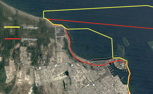
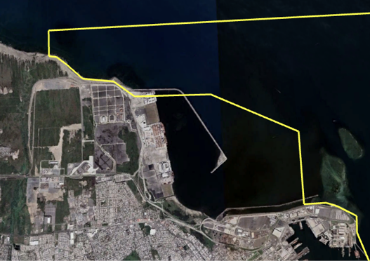
In a second phase, it is planned to build 35 new berths to provide access capacity for deep-draft vessel, this represents the most important and ambitious work in all of Mexico: expanding the port in an area of 500 hectares in water and 450 on land. This would position Tal as the largest in Mexico, being this project a driver of the economy and generator of thousands of jobs. This is demonstrated in its first months of operations, since there has been a growth in container cargo that has reached 2.3 %, in agricultural bulk approximately 5.7 % and in hydrocarbon cargo it has grown 29.1 %(12). For the construction of the new Port of Veracruz, the Government of Mexico in 2012 modified the polygonal of the National Park decreed in 1992, with two main purposes: 1) to disincorporate the Punta Gorda reef and Vergara Bay from the PNSAV 2) increase surface area from the park to the south, arguing that both that reef and the bay were immersed in a process of deterioration with no return and should be excluded from legal protection. It is important to mention that the modification of the decree and the PNSAV polygonal in 2012 was also since the port activities were not compatible in any way with the activities permitted in the park in accordance with the 1992 decree. In fact, it is relevant to note that the original polygonal had encapsulated the port of Veracruz, which prevented it from growing (figure 1). With the new polygonal (which disincorporated an important area of the protection polygon adjacent to the port) it was legally allowed for the port to have the necessary area for the execution of the Port of Veracruz Expansion project(3).
The expansion of the Port of Veracruz has generated a series of environmental impacts in the area, which have been the subject of debate and concern among local communities and environmental groups, due to its impact on the environment, the economy and nearby communities(12).
One of the main environmental impacts of the expansion of the Port of Veracruz is the loss of natural habitats in the beach area. The construction of the new container terminal involved the recovery of land that was previously beach areas, which has generated a loss of natural habitats for various species of fauna and flora that inhabit the area. This has been the subject of concern among environmental groups, who have pointed that this loss of natural habitats can have negative consequences for the ecological balance of the area(13).
Another impact of the port expansion is the increased sedimentation of the marine area. The dredging works carried out to widen the navigation channel and the maneuvering area for ships, which have generated an increase in sedimentation in the marine area, have negatively affected various species of fauna and flora that inhabit the area. This environmental impact indicates that sedimentation can have negative consequences for the marine biodiversity of the area(14). Another point is the increase in emissions. This expansion increased maritime traffic and land transportation, which generates greater emissions of pollutants into the air and water. This can have negative consequences for the health of the people who live in the area, as well as for the fauna and flora that inhabit it(15).
The purpose of this review is to analyze the four stages of transition from the Port to what is currently the port area. The territory gained from nature for its expansion, its growth and the need to establish environmental indicators are observed. The objective is to control the activities that affect the Veracruz Reef System National Park (PNSAV) and to achieve environmentally friendly port services.
II. MATERIALS AND METHODS
A. National Park of the Veracruzano reef System (pnsav) in Veracruz, Mexico
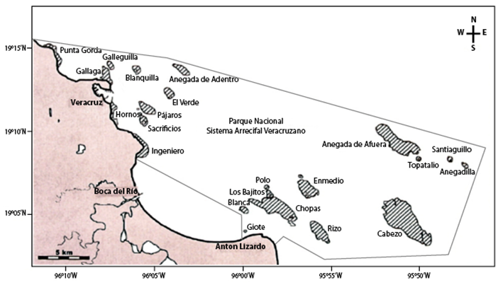
The National Park named ‘Parque Nacional Sistema Arrecifal Veracruzano’ (PNSAV) is in the south-central Gulf of Mexico, off the coast of the state of Veracruz, Ignacio de la Llave. Specifically, between the municipalities of Veracruz, Boca del Río, and Alvarado. It consists of 23 individual reef complexes, which are separated by deep channels. The park’s coral reefs are home of a great variety of marine life, including more than 700 species of fish, more than 200 species of mollusks, and 11 species of sharks. Additionally, the park is considered one of the most important nesting sites for the hawksbill turtle, which is an endangered species(16).
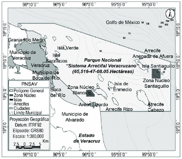
On November 29, 2012, the decree modifying the 1992 decree was published in the Official Gazette of the Federation, declaring it a Natural Protected Area with the character of National Marine Park. The area called Sistema Arrecifal Veracruzano, with a surface of 52 238 hectares, 91 areas and 50 centimeters, was published on August 24 and 25 of 1992 (its modification took place on November 29 of 2012), in whose First Article it was determined that the total surface of the National Park is 65 516-47-08.05 hectares and includes 28 reefs and six keys or islands. The same as in the Official Gazette of the Federation of November 29, 2012, it is designated as the Veracruzano Reef System National Park (figure 2).
It is highlighted that, due to their proximity to the coast, the PNSAV reefs are the most developed reefs in the Gulf of Mexico and are characterized by their resilience to the contribution of fresh water and sediments from the La Antigua, Jamapa and Papaloapan rivers. Coral reefs are the main ecosystem and conservation object of this National Park, they contribute to the mitigation of impacts to the coast caused by storms, hurricanes, and winds such as ‘Nortes’(17).
B. Satellite Image Analysis Using gis Tools
The location of the infrastructure works of the new Port of Veracruz and its coverage area was done through GIS and analysis of satellite images with Google Earth. Some topographic features were also realized through GIS by analyzing satellite images with the use of remote sensing techniques using free-form satellite photographs from Google Earth. For example, available photographs were used with a multi-criteria decision analysis approach (MCDA) (analytical technique that allows identifying several solutions to a problem, using mainly cartographic variables as starting data). Similarly, was used the methodology proposed by Susunaga et al in 2022 (18), due their work observes morphological and area changes, which is useful for this research.
III. RESULTS AND DISCUSSION
A. Analysis and Observation of Changes in the Polygon of the Protected area Using a Timelapse with the Google Earth Pro tool
As can be seen in figure 3 (obtained from the Google Earth program with a photographic layer from the year 1992) the polygon decreed in the official journal of the federation of the National Park ‘Parque Nacional Sistema Arrecifal Veracruzano’ included the Punta Gonda reef and the Bay of Vergara, located north of what was once the Port of Veracruz.
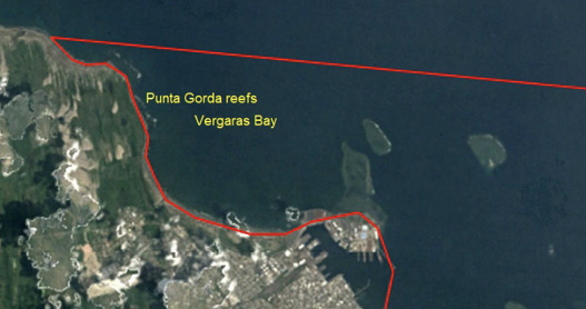
Fig. 3 Polygons of the National Park PNSAV in 1992, include Punta Gorda reef and Vergara Bay (Google Earth Pro, historical image with signs).
From 1992 to 2012, the coastal zone of the polygon in the northern zone, which included Vergara Bay, was used as a traditional artisanal fishing zone and as an emerging tourist zone. It was maintained in adequate ecological conditions due to the scarce interconnection with the City of Veracruz. In addition, anthropogenic pollution was scarce, which allowed the observation of migratory birds and coastal fauna such as turtles, crabs and fish in the vicinity of the beach.
For the year 2012, as seen infigure 4, the National Park polygon was modified by decree in the Official Gazette of the Federation. However, the work for the new Port of Veracruz and its expansion had already begun despite this project was not known until 2014. In thefigure 4can see that the Punta Gorda reef was still alive and almost 50 % of it was excluded from the polygon under the argument that it was anthropogenically intervened. In addition, the construction of the port logistics zone had already begun with an area calculated at 1.4 km2, and a breakwater had already been built in the northern area of the existing port that allowed it to face the numerous climatological events called ‘Nortes’.
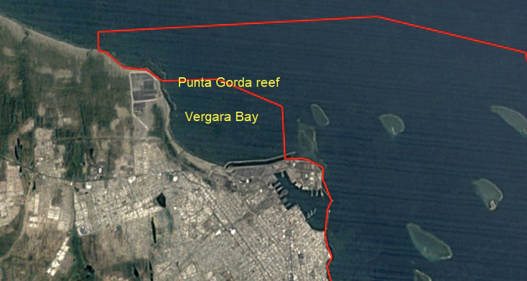
Fig. 4 Polygons of the National Park PNSAV in 2012, exclude Punta Gorda reef and Vergara Bay (Google Earth Pro, historical image with signs).
If we compare the polygon of the original decree of the National Park of 1992 with the modification decreed in 2012 (figure 5) we can determine that the exclusion of Vergara Bay was given to allow the construction work of the new Port of Veracruz. It is called ‘Expansion’, because the project contemplated both rail and logistical interconnection. This park lost a total area of 11 km2 in Vergara Bay and in compensation an area was added in the southern zone that included the Pájaros reef, which in total increased the total area of the park.
B. Analysis and Observation of Changes in the Area of the new port of Veracruz and its Expansion Using a Timelapse with the Google Earth pro tool
In the first stage of expansion, a growth of 25.8 % has been registered in movements in the port, which denotes that during the period from January to May 2019, 11 million 784 372 tons were registered. While, in the same period, before the expansion 9 million 366 096 tons were recorded, where said entries have been in the categories of agricultural bulk, hydrocarbons, mineral bulk, loose cargo, motor vehicles, non-petroleum fluids, vegetable oils, and others(12).
For this reason, a 10-year period was analyzed, taking the range from 2012 to 2022, and using Google Earth Pro, the modifications that the polygon determined for the nature reserve through the PNSAV were analyzed. The following was observed:
Figure 6shows the polygon specified in the Diario Oficial de la Federación (delimited in red) off the coasts of the municipalities of Veracruz, Boca del Río and Alvarado. This polygon is formed by a group of 23 coral reefs of great importance due to their scientific, economic, educational, fishing, historical, touristic and cultural value.
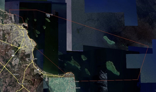
Fig. 6 Polygon of the PNSAV, with an area of 52,238 ha, whose coordinates are 19°08’N 096°00’W (Google Earth Pro, historical image with signs).
Looking atfigure 2, the satellite image from 1992 did not show the beginning of the port expansion works. However, by 2012 (figure 4) can already see the construction of the first logistics areas of the port, which, although they were on land, allow to identify that before the modification of the PNSAV polygon in that year, the port system had already started with the construction of infrastructures, which, when the polygon was modified, were already outside the Arrecifal Marine Park.
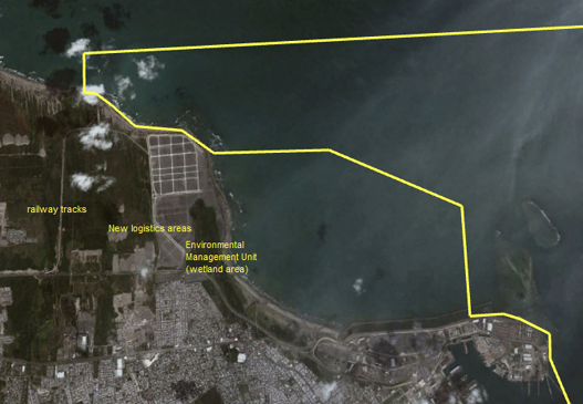
Analyzing only the satellite images in the area where the expansion of the Port of Veracruz took place, this process occurred in the area known as North Beach, including the peripheral area of the San Juan de Ulúa Fortress and the PNAV Polygon which is delimited with yellow color (figure 7).
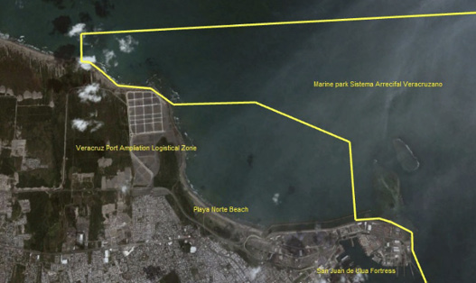
Fig. 7 PNSAV polygon and area of the port of Veracruz, Mexico expansion. (Google Earth Pro, historical image with signs, 2012).
In 2012, infrastructure work had not yet begun in the maritime zone, when the relocation of fishermen settled in this area began (figure 7).
By 2013, infrastructure work continued in the ports land area with the construction of more than 1 000 m2 of new logistics areas, along with the start of construction of the railroad tracks that would connect the port with the rest of the country and the creation of an Environmental Management Unit in a wetlands area that it was decided to conserve (figure 8). It is at this time when access to the beach area was restricted to save peoples safety.
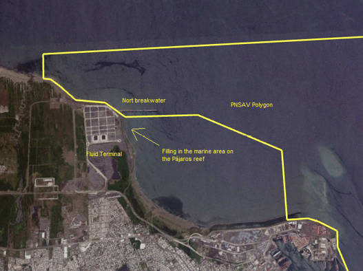
In October 2015, can be seen that the expansion of the port works began by filling in the marine area on the Pájaros reef, the construction of the breakwater (which is located within the PNSAV polygonal) and the construction of the fluid terminal (figure 9).
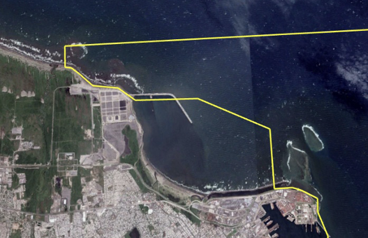
In 2016, the construction of 2.5 kilometers of breakwater, the fluids terminal, new docking positions and dredging continued to give greater depth to Vergara Bay for deep-draft vessels (figure 10).
In 2017, filling 550 m2 began to accommodate the terminals designated in the area for fluid relief (figure 11).
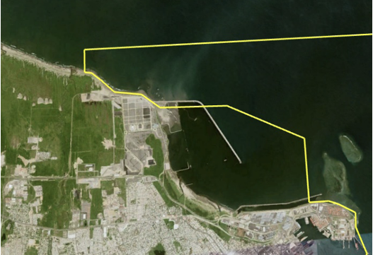
In 2018, the satellite image shows that the filling and growth of said terminal begins, it covers a length of 3.08 km according to the map, and 700 meters from the shore where the beach was inside the sea (figure 12).
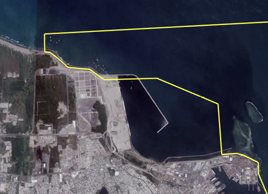
In 2019, deforestation is notorious in the area where the expansion works are being carried out. There were complaints in the newspapers about sand reaching the houses near such works. In 2020 and 2021, work continued the land with areas designated for potential assignees to establish their offices at the port (figure 13).
It can be seen in the satellite image of the year 2021 that the new port of Veracruz begins its operations with the accommodation of vessels and containers.
According to the order presented in the figures, it is shown that the transition stages of the Port from 2011 to 2023 (figure 14) to what is currently the area of the port zone, the territory gained on the shore of the beach (called North Beach) has a total of 2.14 km. This is indicated with a white polygon and the distance with a yellow line (figures 12and13), in addition to participating in nature for its expansion and growth. Derived from this, there are deforested spaces, and part of what belonged to the PNSAV Polygon has been taken for works, of which there is no public documentation where it is known whether the mitigation measures specified in the Manifest of Environmental Impact have been followed, where are described preventive measures for the ‘fauna’ indicator (Chapter VI, Page 3, Table 4). It is essential to establish environmental indicators to control the activities that impact the Veracruzano Reef System National Park (PNSAV) and achieve environmentally friendly port services(15).
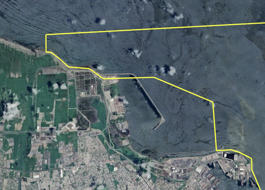
Fig. 14 PSAV Pentagon, Space Mark with construction in Polygon mode in yellow, no construction or work for expansion (Google Earth Pro, historical image with signs, year 2023).
Although it is true that Punta Gorda had a decimated coral community with less than 1 % coverage, this should have been evaluated based on the service it provides to the environmental system. It means, be a buffer zone and a sediment trap, which prevents the rest of the reefs from being buried(3).
The construction and expansion of the Port of Veracruz has brought a series of new companies given the growth of international trade by sea, which has also caused conflicts in the metropolitan area of the City of Veracruz. Among, can be mention the increase in the flow of vehicles that transport containers on the entrance highways, since it is an artificial port exposed to inclement weather, it is closed to navigation in some periods, which delays the shipment of goods, requiring the construction of parking lots for cargo vehicles. Additionally during the year 2023 more than one million cars were exported, which have required the construction of logistics zones that have impacted the coastal ecosystem, since most of them are concrete or asphalt slabs, which has created heat islands that have generated the increase in the temperature of the microclimate of the area, which harms the parks reefs, which significantly damages the ecosystem that has been incorporated since 2006 by the United Nations Educational, Scientific and Cultural Organization (UNESCO) to the World Network of the Program Man and the Biosphere (MAB), “Reserve of the Biosphere”.
IV. CONCLUSION
This national park is a popular destination for both local and international tourism, which comes to explore the natural beauty of the reef system, its biodiversity with permitted activities such as recreational diving and snorkeling, as well as sport fishing. This place is of utmost importance for scientific research, since scientists from all over the world come to study the ecosystems that exist within the park.
Observing the mapping carried out, the port works, and in accordance with what is specified in the environment impact manifestation initial, have not been completed, since the 3,500-meter-long eastern breakwater still needs to be built. The damage that the PNSAV has received is unknown. In the present analysis with the use of the Google Earth Pro tool, is observed that there is an invasion in the polygon that is registered as a PNSAV protected area, also is observed that there are constructions that affected not only the beaches and reefs that were in the area, but also the flora and fauna of the beaches where the work is carried out are denoted as deforested. It would be important to do one more study on the different consequences that may be generated in the environment, not only due to this expansion but also to know what other factors are affecting it.
One of the most important conclusions of this work is that although the Environmental Impact Statement of the Construction and Expansion of the Port was prepared in 2013, with a project that was planned for 2014. The Comprehensive Port Administration of Veracruz (today ASIPONA See) had already made progress in these works, contravening what is stipulated in the General Law for Ecological Balance and Environmental Protection of Mexico, which establishes that this Environmental Impact Statement must be carried out prior to the start of the works of any project.
This park faces several challenges, including pollution, overfishing and climate change, which threaten the health and resilience of its coral reefs and the ecosystems that depend on them. Conservation efforts continue, with a focus on reducing pollution, regulating fishing practices, and implementing measures to mitigate the effects of climate change.
Observing the progress over time of the construction work of the new Port of Veracruz and its expansion, we can determine that an artificial bay was created in order to allow the entry of deep draft ships with a considerable number of containers, which will harm the future the vitality of the reefs that are still within the polygon, affecting the reef flora and fauna, since in recent years due to this increase in load, accidents have occurred within the Reef Park.


