


 Inglés (pdf)
 Articulo en XML
 Referencias del artículo
 Enviar articulo por email
 Citado por SciELO
  Similares en
SciELO
Similares en
SciELO 
 Permalink
Introduction
The historical region of Manchuria (modern Northeastern China) was characterized by rather weak settlement development, which in turn affected the development of the region after the construction of the Chinese Eastern Railway began, accompanied by the development of European-type cities, the key role in the development of which was played by Russian and Japanese urban planners and urban designers. In this regard, the development of Shenyang, which since 1625 was the capital of the Manchu Qing Empire, occupies a special place. Thus, by the time of the beginning of Russian and later Japanese colonization, this settlement was an example of classical Chinese town-planning art, taking into account the regional peculiarities of Manchuria. However, despite such a significant cultural heritage, the development of the modern city center dates back to the period of Japanese colonization, which predetermined the modern planning structure. The purpose of this work is to consider the process of the planning structure formation in the period of the late 19th - first half of the 20th century and to identify the features of the development of urban design during the period of the Manchukuo state within the framework of the Fengtian General plan development in 1935, which largely consolidated the planning structure of the city and predetermined the functional purpose of the districts.
After the Mukden incident in 1931, the Japanese military essentially took control of the entire Shenyang region (Kato, 2006). In 1932, the state of Manchuria was established, and Shenyang was positioned as an important industrial city. The Fengtian Metropolitan City Project (Japanese: 奉天) (The South Manchuria Railway Co. Ltd: Economy Investment Committee, 1935) was developed and implemented, and it became the first complete and comprehensive modern urban plan in Shenyang (Sun & Ikebe, 2023).
Thus, the main research question of thе work is the analysis of the development of Shenyang in the first half of the 20th century, as one of the largest cities in Northeast China in the context of changing political regimes and the application of various approaches to urban design of various architectural schools.
The hypothesis of the study is based on the fact that the development of the urban landscape of Shenyang is based on the principles of urban development of cities in the right-of-way of the South Manchuria Railway (SMR) as part of a local variety of the Japanese colonial urban design school, which absorbed the developments of Russian urban design.
Literature review
Unlike the central regions of China, the history of Manchurian architecture has been studied to a lesser extent. The Russian scientific school played a significant role in the study of the region, due to the study of the architectural heritage of Russian architects and engineers during the construction of the Chinese Eastern Railway (CER) and the white emigration, which in turn was due to both the preserved material heritage and a large number of Russian-language archival materials exported by the Soviet government in the 1940s and 1950s to the Soviet Union. Among the researchers, one can single out Kradin (2010), Levoshko (2003), Kozyrenko et al. (2015) who were mostly engaged in the study of the architecture of Harbin. In the works of Bazilevich (2021), Tceluiko (2022), Smolianinova (2023), individual types of buildings located throughout China are considered. Among Chinese scientists, the works of Chang (1991), Li (1999), Yu (2005) can be distinguished, in whose works individual buildings of various Chinese cities are considered. In general, the issues of urban development in Manchuria during the first half of the XX century have been repeatedly raised in scientific discourse, including the researches of the railway construction development by Denison & Ren (2016), Victoir & Zatsepine (2013).
Shenyang architecture is primarily known for its imperial tombs and palace, which have been studied in many studies of Liang (2005), Guo (2001), Luchkova (2011), Khisamutdinov & Chu (2023), Zhang et al. (2023), Tiange (2023). At the same time, there are significantly fewer publications devoted to the architecture of Shenyang in the first half of the 20th century, especially compared to cities such as Harbin, Changchun and Dalian. Many of them were written by Japanese authors, which is primarily due to the high role of Japan in shaping the appearance of the city of this period: Sato (1981), Fukuda (1976), Chen et al. (1995). The analysis of Japanese influence, in particular its manifestation in the form of the application of the Tatsuno style, is devoted to the works of Dai et al. (2023), Tceluiko & Smolianinova (2023). In general, the role of foreign architectural schools in the development of the architecture of Manchuria, including Shenyang, is considered in the works of Tang et al., Ivanova (2023), Ivanova & Alekseichuk (2023), Lv and Zhu (2009). Individual types of buildings, such as consular offices, banks, train stations, are described by such authors as Smolianinova (2019), Kim (2023), Pugacheva et al. (2024).
The formation of the city genetic code as a classical Chinese city and the influence it had on its development up until the end of the 19th century are discussed in detail in the works of Guo (2001), Luchkova (2011), Puliaevkaia & Lin (2008). They also partially touch upon the stage of the beginning of the transformation in urban planning and urban design as a result of the construction of the southern branch of the CER, which is better known as the SMR. The features of the development of urban planning in Shenyang in the first half of the 20th century are the subject of the work of Sun & Ikebe (2023), where the authors mention that a targeted study of such a topic has not been carried out before. However, despite the significant contribution of this work to the scientific discourse concerning the development of urban design in Northeast China in the first half of the 20th century, this work practically does not consider urban design, although it largely predetermined the features of the formation of city ensembles, some of which have now become cultural heritage sites.
Methods
To study the development of the Shenyang urban structure within the framework of the colonial influence of the first half of the 20th century, a comprehensive analysis and systematization of available archival, literary, digital, cartographic, photographic and video sources were carried out. To fill in the gaps of missing information, an extensive search was conducted in the Russian State Historical Archive, the Russian State Military Historical Archive, and the Russian State Archive of Economics, which revealed the peculiarities of the formation of the city during the period of Russian and Japanese presence. Also, in August and December 2023, full-scale surveys of Manchurian cities, including Shenyang, were conducted, that helped to reveal the peculiarities of the historical street ensembles formation, as well as the impact of planning decisions on their perception.
To collect initial information, empirical research methods were used, primarily morphological analysis of the territory, through observation, description and comparison, which helped to collect initial information about the architecture and urban design of Manchukuo, as well as to identify the features of using the developments of borrowed elements and adapting national ones. The observation method allowed us to conduct field surveys and identify the features of perception of architectural ensembles. The descriptive method was used to characterize the compositional and planning features of urban planning solutions. The comparison method allowed the comparison of the studied urban planning solutions with the techniques of urban planning schools in China, Russia and Japan, as well as between different stages of the implementation of the city general plan.
Due to the high degree of decorative elements transformation and spatial composition of buildings identified in previous studies (Kim and Luchkova, 2018), the main research was focused on the formation of urban design structure as the most stable architecture level. The time frame of the study was deliberately limited to the first half of the twentieth century, because the classical Chinese buildings of the earlier stage have practically not been preserved (with the exception of the imperial tombs, which were actually excluded from the daily life of the city and were originally located outside of it).
The obtained factual material served as the basis for theoretical research methods based on operational methods such as aggregation, analogy, systematization, analysis and synthesis. On its basis, a compositional and morphological analysis of urban development features was carried out and the main patterns of urban development of the city were identified. The hypothetical-deductive method in combination with the mapping method made it possible to create a theoretical model of the development of Shenyang in the first half of the 20th century.
At the same time, the comparison was carried out mainly with the development of cities in Northeastern China (Manchuria), which significantly differed in their development from cities in other regions of China. To understand the prerequisites, architecture development features and urban design in Manchukuo in the context of the political and socio-cultural life transformation of the region, a historical and genetic approach was applied, on the basis of which a periodization of the architecture development in Shenyang was made.
Results
Features of the region development and periodization
As noted above, the active development of the weakly urbanized territory of Manchuria began at the end of the 19th century with the construction of the CER and cities in the exclusion line in the sparsely populated territories of Northeastern China. Russian engineers and architects carried out all the design decisions, despite the involvement of Chinese and Manchurian labor, which gave rise to the claim that “Russia actually colonized the vast territory of China, where the Russian city of Harbin was built” (Li, 1999, p. 97).
This city was built according to the fashionable trends of that time in Russia, which was reflected in its unique architectural appearance. H. Chang in his work says that “The Russian colonialists, remembering their native places, decided to turn Harbin into a semblance of their ancient capital Moscow. And the first thing they did was building churches” (Chang, 1990, p. 3). Of course, this statement is erroneous, because Harbin planning solution reflected the most modern urban planning concepts of Russia at the end of the 19th century, based on the latest achievements of European town-planning art (Levoshko, 2000) and which later organically formed the Russian interpretation of the concept of the “garden city” by E. Howard (1902).
Despite the fact that the ice-free port of Dalian (Dalny) was supposed to be the pearl of the CER, it is less associated with the Russian heritage, although the planning development was laid down by the Russian architect K. G. Skolimovsky. This is largely due to the defeat of the Russian Empire in the Russo-Japanese War (1904-1905) and the handover of the South Manchurian Railway to Japan, which in turn divided the development of the region into two parts-Russian (northern) and Japanese (southern) until the 1930s. At the same time, the Russian zone underwent significant metamorphoses due to the fall of the Russian Empire and a significant reduction in the pace of construction in the 1920s, where paired Chinese cities began to play a leading role (Ordynskaya, 2019).
The zone of Japanese presence on the contrary showed a steady development and formation within the framework of colonial Japanese architecture. At the same time, as Y. Nishizawa (1996) notes, the planning decisions of Russian urban designers formed the basis of the urban appearance of cities such as Shenyang and Changchun.
The unification of the two directions of urban design took place in 1932 after the formation of the pro-Japanese puppet state of Manchukuo. At the same time, the main attention was paid to the new capital Changchun, where new approaches in architecture and urban planning and urban design were fully developed. However, other large cities also received new master plans that carefully integrated the urban design developments of previous eras. Shenyang became one of such cities.
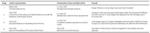
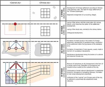
In this regard, it is possible to identify the main stages of the development of architecture and urban design in the southern part of Manchuria. This periodization partially differs from the periodization given in the work of Sun & Ikebe (2023), which also provides 4 periods that are more focused on the stages of urban planning (Table 1).
Traditional Chinese city
In Shenyang construction generally followed the principles of Chinese town-planning art based on the principles of a regular city using individual elements of Manchurian, Mongolian, Korean and other local cultures. In general, the city consisted of three parts. The Inner City received the configuration of a slightly transformed square (Figure 1), represented by a parallelogram (Luchkova and Zadverniuk, 2012). Previously, in Shenyang, as in other oldest cities in China, such as Beijing and Nanjing, there was a fortress wall encircling the entire city, which included 8 city gates. Chaotic buildings developed around the inner city (Figure 2), which was limited only by straight doors connecting the exits from the gate-two on each side of the world,-with the central square.
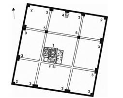
Source: V. I. Luchkova and L. V. Zadverniuk (2012)
Figure 1: Mukden. The scheme of the Inner City plan, 1625-1643: 1 - the forbidden city (imperial palace); 2 - corner pagodas (east, west, south, north); 3 - entrance gates; 4 - ancestral temple; 5 - bell and drum towers
Source: Military Historical Commission for the Description of the Russo-Japanese War of 1904-1905 (1910)
Figure 2: Mukden, сity plan 1905
Basically, the development of this area is represented by numerous typical buildings. They had a brick foundation about a meter high, on which gray adobe walls were erected. It was covered with wooden saws supporting the roof covering of gray burnt tiles. Due to the harsher climatic conditions, the doors were made more massive and stronger than in Southern and Central China. Most of the windows were glazed, but sometimes paper, typical for old Chinese buildings, was used instead of glass. In the center of the Inner City, mainly two-storey houses were built, which had a very low second floor, to which a very steep side or ordinary wooden staircase led (Tambovskii, 1954).
Thus, by the end of the 19th century, the urban design organization of the first historical core of the city was an example of the formation of a classical Chinese settlement. At the same time, the planning structure of the “Chinese square” has been preserved until today (Puliaevskaia and Lin, 2018), however, the historical buildings have been almost completely lost today. As in other Chinese cities where foreign settlements developed, they moved beyond the historical areas and actually formed the satellite settlement, which usually ignores the existing buildings. It was in this vein that the first foreign region subordinated to the Russian administration of the CER began to develop.
Russian settlement
Since the southern branch of the CER was designed to connect Harbin with Dalian, these cities were the main centers of Russian influence on the territory leased from China. The rest of the stations were built more modestly, and their size and expressiveness depended on which class they belonged to.
A distinctive feature of Russian urban design of this period in Manchuria was the use of advanced urban planning ideas, which, in turn, were based on a rethinking of Western urban planning theories. In this regard, the possibility of mass construction of new settlements made it possible to test them. At the same time, both utilitarian settlement stations and stops were built, as well as unique settlements, which, according to both contemporaries and modern researchers (Kradin, 2010, Levoshko, 2000), were the best examples of urban planning thought in the Russian Far East. Such stations included the 1st class stations of Dalian and Harbin. The 2nd and 3rd class stations were distinguished by the relative originality of its designs. It shows a rethinking of the concept of a garden city from the point of view of the compositional organization of space, which was typical for Russian urban design of this period.
Thus, the railway station in Shenyang belonged to the 4th class (Al’bom sooruzhenii i tipovykh chertezhei Kitaiskoi Vostochnoi zheleznoi dorogi. 1897-1903, 1904) and was located at a small distance to the west of the Chinese center, where the railway ran around the entire city. Thus, the plans of the Russian Empire did not include the creation of a large settlement on this site. Probably, such distancing from the largest Chinese city in the region was caused by the Chinese government’s demand for the establishment of protective zones 16 km from the imperial cemeteries (Lukoianov, 2008), which limited the development potential of the settlement as a large railway station.
According to the plans of standard structures (Figure 3), a passenger building, a fanza for the Chinese, a station barracks, a travel barracks, traffic service buildings, a reservoir building, 12 places for the development of residential premises, as well as gardens were supposed to be erected in the city. The construction of a higher-class station would require the construction of additional facilities for the maintenance of rolling stock, which was problematic due to the limitations mentioned above.
Source: Al’bom sooruzhenii i tipovykh chertezhei Kitaiskoi Vostochnoi zheleznoi dorogi (1897-1903)
Figure 3: Standard layout of the 4th class station
In general, Russian settlement did not receive any significant development and did not have a significant impact on the development of the planning structure of Shenyang due to both the secondary importance of the station and the imminent loss of the southern section of the CER by Russian Empire after the defeat in the Russo-Japanese War.
Japanese settlement
After Russia’s defeat in the war under the Portsmouth Peace Treaty (23rd August (5th September) 1905), Shenyang fell into the zone of Japanese control. The railway line acquired by Japan between Changchun Station and Lushunkou (Port Arthur) was renamed into the SMR.
A distinctive feature of Japanese urban design in Manchuria was the adaptation of the existing Russian planning system, primarily represented in Dalian, which, according to Japanese researchers, is influenced by baroque forms (Mizuuchi, 1985), while Russian engineers laid in them the idea of a Russian interpretation of a garden city, as well as a combination of classicism and modernism in urban design (Levoshko, 2000). At the same time, the author of the project himself in his report mentioned only the compositional advantages of using “French” radial and ray and the disadvantages of “American” orthogonal street systems (Scolimovskii, 1904). All this led to the active use of radial and ray systems, which were primarily used in such large cities as Shenyang, Changchun and Dalian. At the same time, in other colonial cities of Japan and the metropolis, such a practice was not widespread (Lee & Yang, 2023), which demonstrates the regional peculiarity of urban design and requires further study of this issue in the framework of a separate work.
Thus, the master plan of the station that Japanese architects erected (Figure 4A), had a geometric shape, and, apparently, reproduced a typical project, or at least had certain elements used by Japanese urban designers: the railway station was the main center of the composition, from which the main composite axes diverged in three directions, the main of which ran perpendicular to the railway line. Also, the organization of the intersection of six main streets has become a recognizable element, where a ring road is arranged at the intersection of two perpendicular and one diagonal lines, forming a city square.
It is worth noting that this planning structure partly echoes with the standard planning solutions of the CER railway stations from the 2nd class, where it was planned to make divergent lines. Of course, this approach was primarily conditioned by the need to load traffic flows and was tested in Europe and America back in the 19th century. It is also worth noting the rigid regular layout characteristic of Asian cities, which is based on plots with proportions of 1 to 2, which is a feature of the Japanese system of proportionation, which in turn combine into square-proportioned blocks of 8 plots.
The presented plan (Figure 4B) clearly shows a significant difference in the approach to the organization of planning decisions of the colonial and native parts of cities, which was also aggravated by the unauthorized construction of the Chinese part of the city, due to the weakening of urban design regulations during the period of the Republican government.
Source: M. Hanai (1925)
Figure 4: Map of Mukden during the period of Japanese domination. (A) The plan of the station territory of the Japanese concession in 1925. (B) The city plan in 1925.
It is also worth noting the international trade zone, which was administratively subordinated to the Republic of China, which was located between the old Chinese city and the SMR exclusion zone. Numerous connections passed through this area, represented both by wide highways connecting the railway station with the Inner City, and by various secondary roads. Despite the fact that they tended towards the orthogonal configuration of the grid of blocks and the rectilinear configuration of the main streets, their planning structure was more chaotic compared to the zone under the control of the Japanese administration.
The main part of the Japanese development was located within the boundaries of modern streets: Shengli Bei Street (胜利北街), Shifu Road (市大大路), Nanwu Road (南五马路) and Heping Bei Street (和平北大街), and the first was the main one due to the fact that it was originally laid out as a stand-in for the railway. In this research, the development of the designated area along the main compositional axes laid down during the Japanese occupation is considered: Shenli Bei Street (胜利北北), Zhonghua Street (中华路), Zhongshan Street (中山路) and Minzhu Street (民路路). These are the streets that converge from three ways on the main accent of the whole composition-the railway station. Analyzing the preserved buildings of the selected streets, it is worth noting the large number of preserved buildings in the historical center (Figure 5).
Along the streets of Shenli Bei, Zhonghua and Minzhu, chaotically scattered buildings are mainly concentrated, which either housed administrative buildings or are semi-barracks in poor technical condition. Today it is difficult to fully assess the ensembles of streets, since the former multi-storey buildings, many of which were accentuated, have lost the status of high-rise dominants due to the abundance of skyscrapers dispersed in the building.
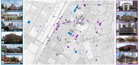
Source: drawings by the authors, photos by the authors, maps.baidu.com.
Figure 5: Map of the distribution of architectural heritage sites from the period of Japanese influence: blue - from 1905 to 1932; purple - from 1932 to 1945. The objects indicated on the map: 1 - The first branch of the Chinese Medical University Hospital, 1909, Zhongshan Road № 97a; 2 - The former site of the Taitian Branch of Toyo Takusuke Co., Ltd., 1926, Zhongshan Road, 101a; 3 - The Yamato Hotel, 1929, 97 Zhongshan Road; 4 - Fengtian Branch of the Manchurian Railway, 1907, 99 Zhongshan Road; 5 - Fengtian Branch of Yokohama Specie Bank, 1925, 104 Zhongshan Road; 6 - The former Fengxian Post Office, 1914, 50 Zhongshan Road; 7 - The former site of the Xinnong Cooperative, 1932, 43 Heping South Street; 8 - The former location of the branch of the Central Bank of Manchuria in Tiede, 1932, 312 Nanjing North Street; 9 - The former office building of a Japanese foreign trade company, 1937, 107 Minzhu Road; 10 - the former site of South Manchurian Railway Co., Ltd., 1935, No. 2 Taiyuan North Street; 11 - the site of Mitsui Bussan Kaisha Building, 1937, 108 Zhongshan Road; 12 - The former site of Zhicheng Bank, 1935, 118 Zhonghua Road.
This historical area of the former Japanese concession, where numerous mansions surrounded by gardens and parks were built, stood out noticeably from the general background of the city. A. Tambovskii (1954, p. 25) describes this area as follows: “In the area of the concession there were also multi-storey buildings of Japanese administrative institutions, offices, banks, commercial and industrial firms. The European-style houses in this area alternate with small, very low one- and two-storey Chinese buildings, mainly shops and handicraft workshops”. It can be noted that at present the mentioned “small” buildings have not been preserved, numerous modern shopping malls and skyscrapers have been erected on their site. At the same time, the buildings of various institutions in which administrative and commercial organizations were located have been preserved and have reached our times. All these historical buildings influenced the imaginative solution of the surrounding high-rise modern buildings, most of which repeat the decorative elements, materials and color of the decoration of historical buildings.
It is worth noting that the appearance of red brick buildings in Shenyang creates a completely different modern urban atmosphere than the gray Manchurian brick used in building materials in the Republican era. It contributed to the identification of Japanese architecture with red brick among local residents.
The densest historical development is located along Zhongshan Street, which turns into the square of the same name, on which all of the buildings are monuments of cultural heritage. It is necessary to pay attention to the ensembleness of this square, despite the different periods of construction of buildings. This is largely due to the stylistic features in which most of the buildings forming the facade of the square were erected in the Japanese imitation of the classical Western style (colonial seiyokan), which gave this square a great status and representativeness. During the period of the Japanese administration, the Yamato Hotel (1929), a branch of Yokohama Shengjing Bank (1925), a police department (1929), a branch of the Bank of Korea (1920), a branch of Toyo Takusho Co., Ltd. (1926), an office of Fengtian Mantetsu Co., Ltd. (1907), the first branch of the Chinese Medical University Hospital (1909) were built on this square. Only the Mitsui Yoko Building (1937) belonged to the Manchukuo period, which is strikingly different in style features based on the principles of functionalism, which manifested itself in Manchurian architecture much later than in Europe and America.
This square was and still remains one of the key squares of the city, as well as Zhongshan Street, connecting it with the station square, also still has an important role in the life of the city and its infrastructure. Despite the fact that the city center is being built up with numerous modern high-rise buildings, the historical part still remains accentuated and presentable against the background of faceless skyscrapers. Exactly the historical buildings, due to its imagery and number of floors, are more harmonious and proportionate to people. It contributes to the location of walking areas near these buildings in the core of the historical city.
Formerly many buildings in this district were decorated with Japanese red brick tiles, which faded over time, which significantly worsened the visual perception of the area. As a result, the buildings were restored and now have not a classic brick color, but a darker brown, however, all plastered elements also stand out in contrasting white color framing the window openings and the cornice line, which refers to the special Japanese architecture of the Tatsuno style, where a number of compositional techniques were based on this contrast.
As you move along the designated streets towards the station, the local dominant opens up better and better-the railway station, built in 1910. The facade of the building is also finished with dark brown brick tiles, which are framed by contrasting white elements, which will be actively used in the Tatsuno style in the future. Thus, openings, towers flanking the main volume of the building, interstory draughts, as well as a cornice belt with stylized medallions in the form of brackets and triglyphs are accentuated in white. Predictably, the greatest emphasis is placed on the entrance group, where due to vertical white matrix inserts organically combined with the decor of window openings, the effect of increasing the height of the object is achieved. It is worth noting the entrance arch, decorated with metrically alternating white and brown inserts, an element that will later be used in many public and administrative buildings.
The station forecourt is decorated in a single style using all the same materials and compositional finishing techniques, which makes it possible to form an ensemble of the square. To connect the composite axes, the technique of fixing the axes on an accent object, known since the 16th century, is used. At the same time, buildings with tower completion became such accents for the studied streets, which also fulfilled the functions of high-rise dominants before the advent of modern high-rise buildings. They included from five to six floors, while ordinary street buildings consisted mainly of two or three-storey buildings.
Thus, during the development of this area of the city, under the control of the Japanese administration, not only the planning structure was laid, but also ensembles of the main streets that have survived to the present day were formed. At the same time, the compositional techniques used in urban design were based on a combination of classical European urban design techniques with the peculiarities of Asian proportioning, which created a unique urban environment characteristic of Japanese colonial settlements.
The Manchukuo period
On March 1, 1932, a nominally independent “state of Manchuria”, Manchukuo, was proclaimed within Southern and Northern Manchuria, which became a puppet entity in the sphere of influence of Japan. The last Qing Emperor Pu Yi was put by the Japanese at the head of a limitrophic country, which in 1934 became known as the “Manchurian Empire”-Manchukuo with its capital in the newly renamed Xinjing (now Changchun). Mukden (Shenyang), in turn, was renamed into Fengtian, and existed under that name until the end of World War II.
Due to the fact that all the main functions of the state center have now been transferred to Xinjing, Shenyang has not made much progress in its development against the background of the newly created capital. The territory of the city slightly increased, only a few building areas appeared, which were erected according to the typical principles of division into a straight-angle grid of blocks laid down at the previous stage, with the allocation of several main streets that differed in greater width. The main development of the new construction was concentrated in the area nearby to where the Japanese settlement with its railway station was located. The axes of the existing streets were extended and logically supported by another diagonal axis, which was located perpendicular to the existing one, thereby completing the zigzag within the main thoroughfares. In general, the new layout was characterized by an increase in the scale of the blocks, which indicates an increased area of buildings under construction, as well as an orientation towards industrial production of new areas.
Of interest is the division of the southern quarters (Figure 6), built by private houses. Here an attempt to abandon the rigid intra-block division into an orthogonal grid has been made. It has been replaced by an orderly picturesque layout. Such techniques were not typical for the architecture of Northeastern China, but attempts to apply them in Southern China were typical back in the 1920s (Kim, 2020). In the center of which there was a pedestrian square, which indicates attempts to humanize public spaces, but it is not possible to reliably establish the features of their development due to the loss of not only objects located in this place, but also planning features.
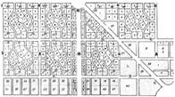
Source: Fengtian mingxi da ditu (1935)
Figure 6: The principle of dividing blocks according to an orderly picturesque layout. (A) The location of the blocks on the map of the station district. (B) An example of the rejection of a rigid intra-quarterly division into an orthogonal grid.
It is also necessary to note the development of the former international trade zone, the southern part of which is strikingly different from the rather chaotic northern one. Here, the planning follows a rigid orthogonal structure based on square blocks, which makes the division larger compared to the Japanese period.
Architectural objects also tended to adhere to the Japanese style due to Japan’s de facto hegemony. The presence of Japanese architects and engineers in the state can be traced to architectural objects erected after the establishment of the new regime of government.
During this period, in the area of Shenyang Station and Zhongshan Square, the key administrative facilities of the Kwantung Army, public service facilities were located: Mantetsu Railway Department, Mukden Police Department and Mukden Postal Department, thereby forming a modern cluster of administrative facilities (Sun and Ikebe, 2023).
If you look at the map (Figure 5) of the preserved monuments of the cultural heritage of the period of Manchukuo’s existence, it can be noted that these objects are already more scattered, and not grouped in one center, as was the case with the buildings of the period of the Japanese occupation. Two directions of construction development can be distinguished: filling in the gaps of the street facades of the Japanese period and building the western district of the city, located across the railway line from the former Japanese colony.
Basically, these objects also represent administrative and commercial institutions and are distinguished by their monumentality and subordination to a single style. There were also two stylistic trends during this period: the Japanese colonial style (colonial seiyokan) and Western European neoclassicism, which turned into functionalism.
The Japanese colonial style was the predominant style in the design of administrative buildings throughout Manchuria. This style, like the earlier Tatsuno style (Tceluiko and Smolianinova, 2023), is distinguished by the contrasting use of white stone wall elements and basement cladding as accents on a wall made of Japanese tiles imitating red brick. In general, the composite and volumetric planning solutions of Manchukuo buildings of the early periods are a logical continuation of the development of colonial architecture of Japan, which is primarily due to the involvement of Japanese architects in the design of local buildings. The main thing that significantly differs Shenyang from Harbin is that even in the 1930s Russian architectural school, represented by the projects of architects of the Russian emigration, was traced.
It is also worth noting the creation of a new style that would show the uniqueness of Asian architecture and the superiority of local traditions over European ones. In this case, a technique already practiced in Japanese architecture was borrowed, in which elements of different cultures were integrated, where the facades were executed in a Europeanized form, while the completion was stylized Chinese tiled roofs with characteristic slopes, which were an integral attribute of East Asian and primarily Chinese architecture. However, despite some archaic ideas, such buildings are primarily characterized by the influence of modernity, internationalism and functionalism (Sewell, 2019). This style is called teikan yoshiki (imperial crown style) and was actively used both in Japan itself and in dependent territories and colonies. In Manchukuo, such stylistic techniques were primarily used in government buildings, which was supposed to form a stable idea of the image of Manchurian architecture.
Thus, the development of both town-planning art and architecture of the Manchukuo period is a direct continuation of the development of Japanese colonial architecture, which is due to both the high degree of influence of Japan on the life of the puppet state and the active participation of Japanese architects in the design of objects. The short period of Manchukuo existence led to the fact that its own architectural school was never formed here (Figure 7).
Discussion
An analysis of the development of the urban structure of Shenyang showed an example of the development of cities located in the exclusion zone of the South Manchurian Railway. Meanwhile, based on this and previous research (Pugacheva et. al., 2023), we can talk about the key role of the influence of the Japanese architectural school on the formation of the appearance of the city. It is worth noting that despite the centuries-old history of Shenyang, its historical Chinese core has given way to a new district being built on the site of foreign settlements, which is typical for many cities located in the areas of settlements and concessions.
Thus, the modern historical core formation is primarily related with the development of the city planning structure in the first half of the 20th century. Meanwhile, the city received the greatest growth during the Japanese colonial period, with its area increasing by two times. During the Manchukuo period, the city began to develop due to active industrial construction, which increased its area by 70%. Over this period a transport network has been laid, which to this day determines the planning structure of Shenyang. The new approach to urban design, which was used by architects of that period, greatly changed the appearance and style of the city, while Japanese architects played a leading role in the development and defined the appearance of Shenyang in the first half of the 20th century. As a result, the buildings were not crowded into densely built-up blocks but were lined up along straight, wide streets, visible from several sides, thereby forming ensembles of open squares and street facades.
The Russian School of Architecture, unlike in Dalian and in the cities located on the line of the CER, had almost no impact on the development of local architecture and urban design. It happened largely due to the secondary importance of the city for the Russian administration and the small period of presence in this area.
Conclusions
In the course of the work, the features of urban design of Shenyang in the first half of the 20th century were comprehensively analyzed for the first time in the context of the change of political regimes and, as a consequence, the influence of various schools of urban design.
The author’s periodization of urban design in Shenyang has been developed and compared with the periodization of urban planning development, presented in the work of Sun & Ikebe (2023). The comparison revealed that urban planning preceded urban design in the development of the CER project. However, subsequent changes associated with the change of administration were first reflected in urban design, while urban planning required more time to make changes. An exception is the last stage, where the formation of Manchukuo entailed almost instantaneous changes in all areas of architectural design.
An analysis of the development of the city’s planning structure before the start of foreign expansion revealed that it developed in accordance with Chinese urban planning traditions as a regional center. During the period of the Russian administration, the designed station had a secondary significance, which was also reflected in the utilitarian planning structure of Russian quarters. One of the main decisions of this period was the location of the station itself at a distance from the historical Chinese core, which predetermined the development of the new city center in later periods.
The city received the greatest development after the transfer of the SMR right-of-way rights to the Japanese administration, which raised the status of the station, making it one of the main points of the railway, and also laid down the extant planning system, the center of which was the railway station. The planning structure was dominated by a grid-system with unloading diagonal beams. At the same time, the main development took place within the right-of-way, which made the overall planning structure of the city fragmented. The blurring of these boundaries and the formation of a unified system began only after the transfer of land rights to the government of Manchukuo, which began to implement comprehensive territory development plans.
Thus, the works devoted to both the features of urban planning and the analysis of individual objects of architectural heritage that make up the urban ensembles of the city were summarized. The analysis of the development of Shenyang showed the continuity of its development model with the main stages of the formation of cities in Northeast China located in the exclusion zone of the South Manchurian Railway, where the Japanese colonial urban planning school played a prevailing role, as well as its regional manifestation in the form of the Manchukuo urban design school.
Recommendations
The architecture of the Manchukuo period in this region is an integral part of the development of Japanese colonial architecture. In this connection, in the course of further research, it is necessary to identify the features of the formation of the urban design structure of cities located in the northern regions of Manchuria and located in the exclusion zone of the CER, where the Russian architectural school played a key role in development. The analysis of these two directions of development will make it possible to identify the genotypes of such cities and build a theoretical model of the evolution of urban design systems in the region, as well as the imaginative solutions of buildings located there, depending on the level of influence of Japan or Russia.

